
Geirangerfjord
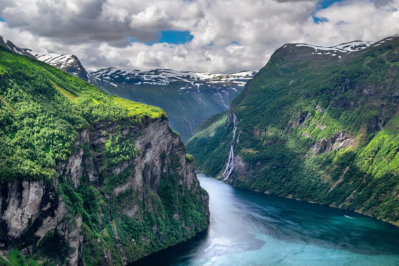
Geirangerfjord is widely regarded as the crown jewel of Norwegian fjordland, stretching 15 kilometres (9.3 miles) into the heart of the western Norwegian highlands in Møre og Romsdal county. Inscribed as a UNESCO World Heritage Site in 2005 alongside Nærøyfjord, it plunges to depths of 260 metres and is hemmed in by near-vertical cliff faces rising over 1,400 metres above sea level. Seven iconic waterfalls — most famously the Seven Sisters, the Suitor, and the Bridal Veil — stream freely down the rock walls in spring and early summer, fed by snowmelt from the surrounding peaks. Considered one of the most scenically dramatic fjords on Earth, Geirangerfjord draws over 700,000 visitors annually, making it Norway's single most visited natural attraction.
🌍 Geography and Ecosystem
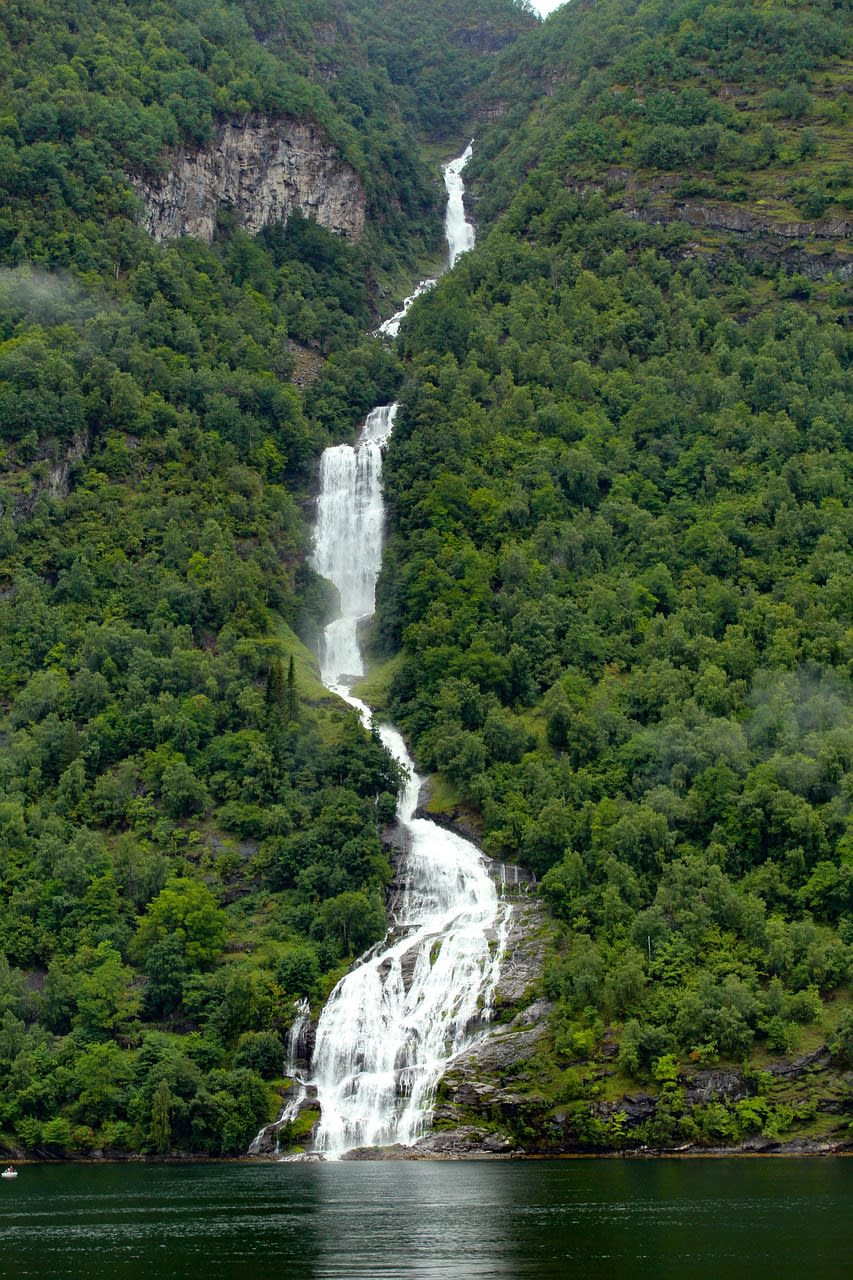
- Seven Sisters Waterfall: Norway's fourth-tallest waterfall at 410 metres, consisting of seven separate streams that plunge unbroken from the plateau edge into the fjord. Flow peaks in May–June from snowmelt, and the individual streams visually merge and separate depending on precipitation levels.
- Dalsnibba Viewpoint: At 1,476 metres above sea level, this viewpoint reached via the Nibbevegen toll road offers a bird's-eye panorama of the entire fjord system. Snow cover can persist here until late June, and the plateau supports Arctic-alpine flora including mountain avens and purple saxifrage.
- Flydal Gorge: A photogenic narrowing of the fjord near Geiranger village where the emerald water deepens to sapphire blue. The reflections of surrounding cliffs and waterfalls in calm conditions create one of Norway's most reproduced landscape photographs.
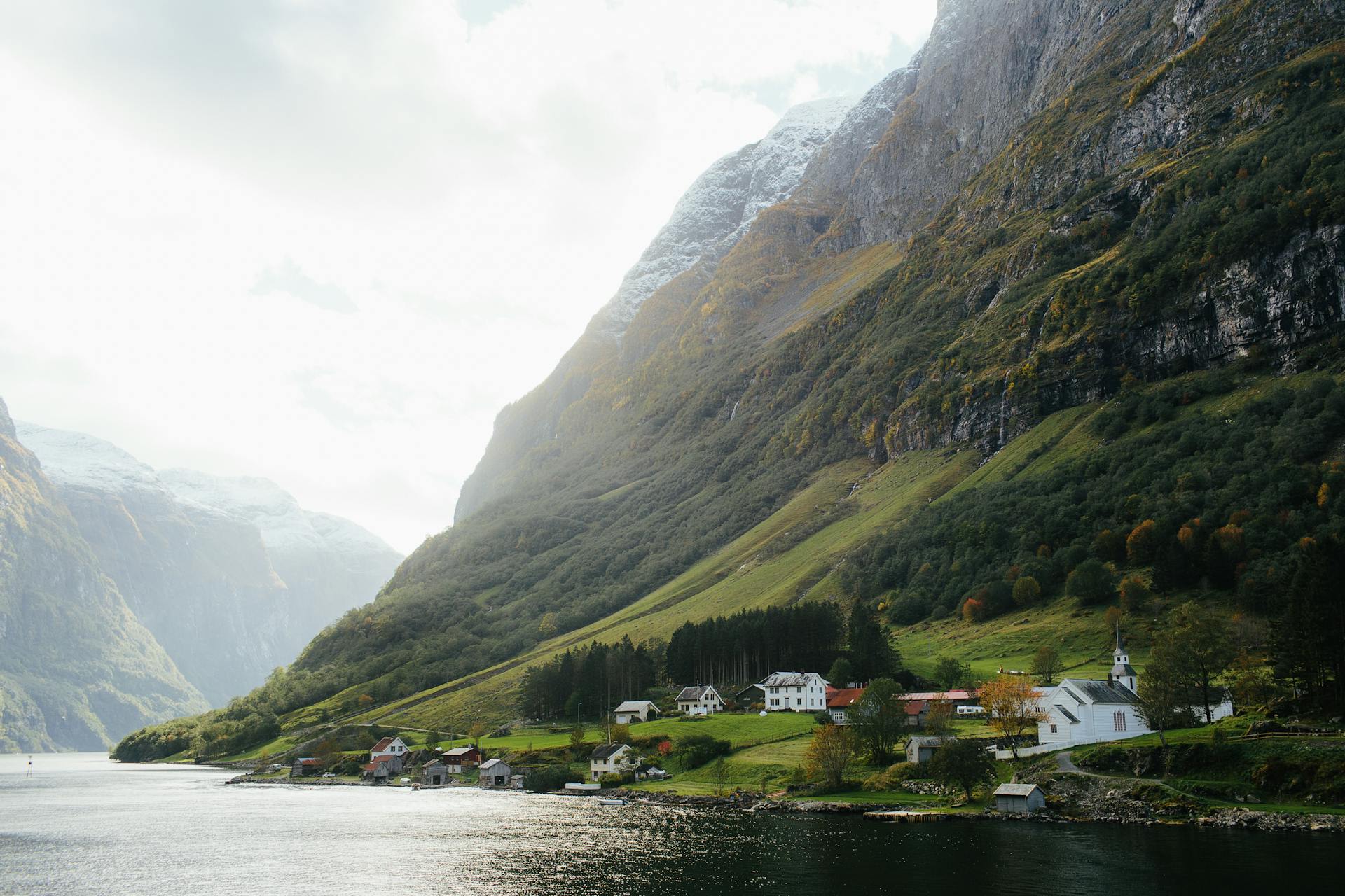
- Abandoned Cliff Farms: Isolated farmsteads such as Skageflå and Knivsflå, accessible only by steep hiking trails, were inhabited until the 1900s. Their remaining stone walls, sod roofs, and terraced fields offer a compelling window into the extreme self-sufficiency of traditional Norwegian rural life.
📜 History and Cultural Significance
The fjord gained international recognition in the late 19th century when the first organised tourist steamers began operating in 1869, introducing wealthy British and German visitors to Norway's inland waterways. Kaiser Wilhelm II of Germany was a celebrated regular visitor between 1889 and 1914, anchoring his imperial yacht in the fjord and famously declaring it the most beautiful place on Earth. The tourism infrastructure that grew around his visits — hotels, roads, viewpoints — established the template for modern fjord tourism. UNESCO designation in 2005 formalised international recognition of the fjord's outstanding natural and cultural value, placing it alongside landmarks such as the Grand Canyon and the Galápagos Islands on the World Heritage List.
🏃 Activities and Attractions
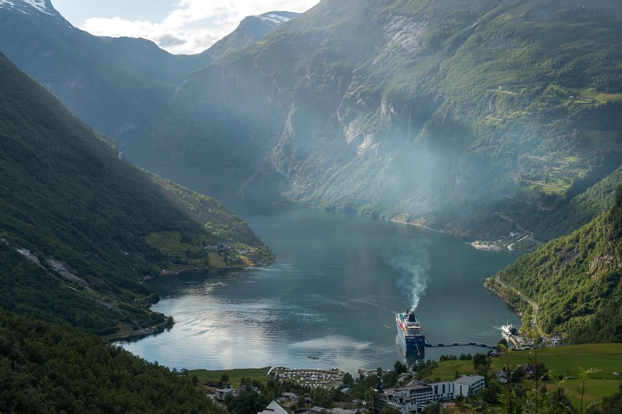
- Fjord Cruises: Year-round ferry services and summer sightseeing boats operate between Geiranger and Hellesylt, passing directly beneath the Seven Sisters and Suitor waterfalls. Small RIB (rigid inflatable boat) tours allow passengers to venture directly under the spray of falling water — an experience impossible by conventional vessel.
- Kayaking: Sea-kayaking the fjord at dawn or dusk, when cruise ships are absent, provides an extraordinarily serene perspective. Paddling beneath the 400-metre waterfall curtains with only the sound of falling water is described by many as a once-in-a-lifetime experience. Several rental operators in Geiranger village offer guided half-day and full-day tours.
- Hiking to Viewpoints: The Ørnesvingen (Eagle Road) hairpin road with 11 bends offers roadside panoramas, while the 2-hour hike to Storseterfossen waterfall lets you walk behind the falling water. The longer Skageflå hike (4–5 hours return) reaches one of the abandoned cliff farms at 250 metres elevation.
- Nibbevegen Mountain Drive: Norway's highest public road climbs from sea level to 1,476 metres in just 22 kilometres, with spectacular views at every hairpin bend. The toll road is open from late May to October depending on snow clearance, and the Dalsnibba Skywalk platform extends 30 metres over the cliff edge.
- Winter Snowshoeing and Skiing: From December to April, guided snowshoe tours depart from Geiranger village into the surrounding alpine terrain. Cross-country skiing from the plateau above the fjord provides sweeping winter vistas rarely seen by summer visitors, and avalanche-aware guides open terrain otherwise inaccessible to independent travellers.
💡 Travel Tips
Getting There: The nearest airport is Ålesund Airport Vigra (AES), approximately 85 km northwest. From Ålesund, reach Geiranger by bus (4–5 hrs, seasonal) or by driving the E136 and Rv63 — the latter crosses the famous Trollstigen mountain road if approaching from the south. The Geiranger–Hellesylt ferry is part of the driving route and must be booked in advance in peak season. Oslo is roughly 7 hours by car via the Rv15.
Accommodation: Geiranger village (population ~250) has several hotels including the historic Union Hotel (opened 1891), campsites directly on the fjordshore, and a handful of guesthouses. Book at least 3 months in advance for July stays. Ålesund and Stryn offer larger accommodation options within 1.5–2 hours' drive.
What to Pack: Waterproof jacket and trousers are essential year-round — the fjord generates its own microclimate with frequent rain showers. Layers are critical as temperature swings of 15°C between fjord bottom and Dalsnibba plateau are common. Insect repellent for midsummer hiking. Binoculars are worthwhile for spotting waterfalls and cliff farms from the boat.
Permits and Fees: No entry fee for the fjord itself. Nibbevegen toll road costs approximately NOK 160 per vehicle (2024). Cruise ships are subject to emissions regulations since 2026 requiring zero-emission vessels in the UNESCO zone — check your cruise line's compliance status.
🌱 Conservation
Land-based pressures include erosion along the most heavily trafficked hiking trails, particularly the path to Skageflå farm, where exposed tree roots and compacted soil indicate excessive foot traffic. Statens naturoppsyn (Norwegian Nature Inspectorate) manages trail hardening and visitor flow through guided tour requirements on the steepest sections. Invasive species — notably Himalayan balsam and giant hogweed — have colonised disturbed ground near the village and are subject to ongoing removal programmes. The cliff farms themselves are maintained through a heritage grant scheme that subsidises traditional farming practices to keep the cultural landscape open and legible for future generations.