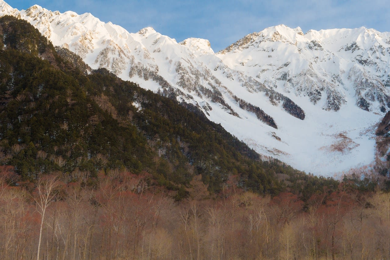
Kamikochi
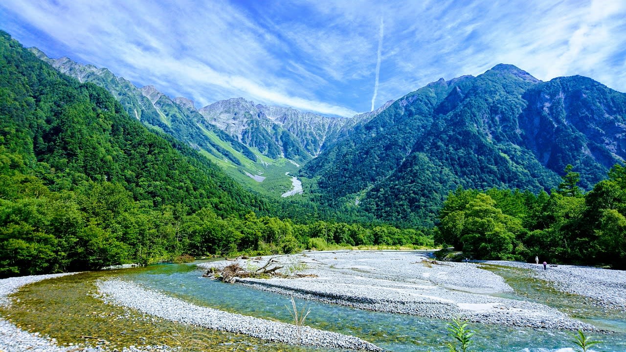
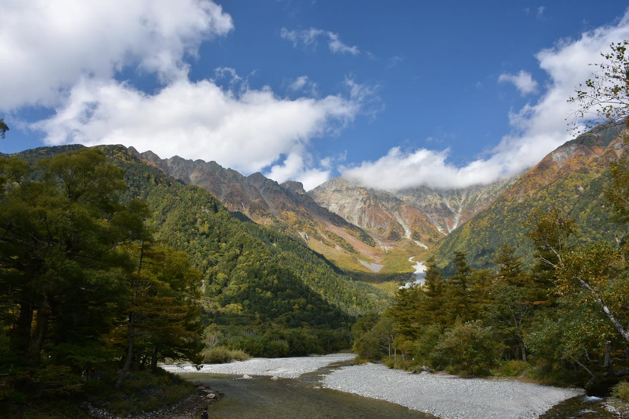
Kamikochi is a 15 km glacially carved highland valley in Nagano Prefecture, central Japan — at 1,500 m elevation in the heart of the Hida Mountains (Northern Japanese Alps), surrounded by a ring of peaks exceeding 3,000 m including Hotaka (3,190 m, the third highest peak in Japan), Yari (3,180 m, Japan's 'Matterhorn'), and the active volcano Yake-dake (2,455 m). The valley is designated a Special Natural Monument and Special Place of Scenic Beauty — the highest dual natural protection designation in Japan — and has been closed to private vehicle access since 1975, requiring all visitors to arrive by scheduled bus or on foot through the Kama Tunnel. The Azusa River flows crystal-clear through the valley floor, fed by glacial melt and mountain springs, with the clarity and aquamarine colouring of water emerging directly from high alpine snowfields. Kamikochi is the starting point for ascents of the highest peaks in the Japanese Alps and one of Japan's most beloved alpine landscapes — it was described by the British missionary Walter Weston (who climbed here in the 1890s) as 'one of the least spoiled and most beautiful valleys in Japan', a judgement that retains its validity today.
🌍 Geography and Ecosystem
- Taisho Pond: The Taisho-ike at the valley entrance is a lake formed in 1915 when the Yake-dake eruption dammed the Azusa River — its surface studded with the bleached trunks of larch trees killed by the volcanic flooding, reflected in still water with the Hotaka peaks behind. The dead trunk landscape within the living mountain reflection is one of Japan's most distinctive photographs — the contrast of ghostly white wood, dark water, and snow peaks captures the Japanese aesthetic of wabi-sabi (beautiful imperfection) with extraordinary precision.
- Kappa Bridge and Hotaka Peaks: The Kappa-bashi (Kappa Bridge) at the valley centre is the symbolic landmark of Kamikochi — a wooden suspension bridge over the clear Azusa River with the Hotaka massif filling the skyline behind. The view from Kappa Bridge upstream toward Hotaka peak is the most classic Kamikochi composition. The bridge is busy in season but magnificent in dawn light before the buses arrive from Matsumoto. The valley flat around Kappa Bridge is the best Japanese macaque (nihonzaru) habitat — the troops are habituated to human presence and move freely through the picnic and trail areas.
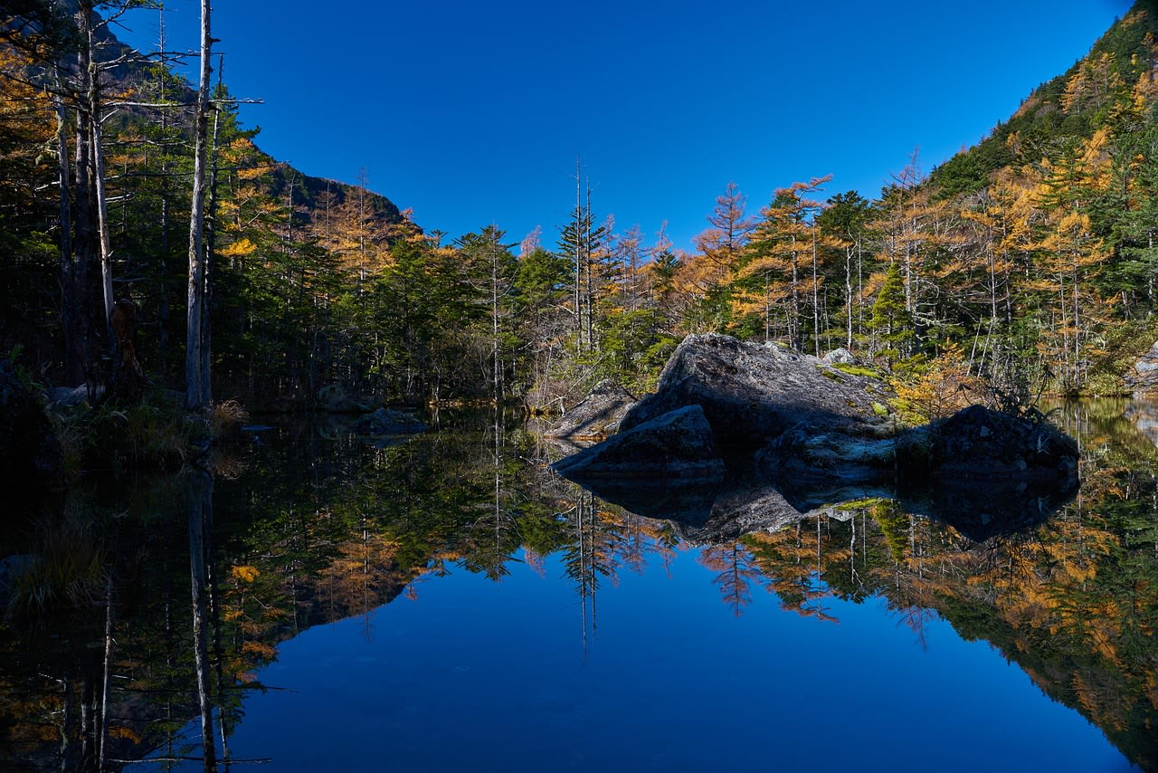
- Myojin Pond: A 2 km walk north of Kappa Bridge, Myojin-ike is a sanctified pond at the foot of the Myojin peak, its surface an extraordinary deep blue-green fed by underwater springs and surrounded by old-growth forest of Japanese larch, white birch, and fir. The Hotaka Jinja mountain shrine on the pond shore holds an annual ceremony in October at which mountain climbers' prayers are floated on the water. The combination of still water, ancient larch, and small Shinto structures gives Myojin a quality of spiritual landscape absent from the more crowded areas near Kappa Bridge.
- Autumn Foliage: Kamikochi's autumn colour (late September–late October) is among the finest in Japan — the combination of Japanese larch (which turns gold), white birch (yellow), rowans and maples (red and orange), and the dark backdrop of fir forest creates a layered colour display against the grey granite peaks that attracts hundreds of thousands of visitors annually. The peak colour window is short (1–2 weeks) and timing varies by year and elevation, but the combination of larch gold and mountain snow (first snows often arrive in October) is uniquely Japanese Alps in character.
📜 History and Cultural Significance
The Kamikochi Teikoku Hotel — opened in 1933 and still operating as the Kamikochi Imperial Hotel — established the valley as an elite Japanese highland resort in the pre-war period, attracting intellectuals, writers, and the Imperial family. The hotel's alpine architecture and the surrounding valley remain among the most aesthetically coherent resort landscapes in Japan.
🏃 Activities and Attractions
- Valley Walk (Taisho-ike to Myojin): The 6 km flat walk from Taisho Pond to Myojin Pond via Kappa Bridge is the core Kamikochi day experience — through old-growth forest along the crystal Azusa River, with mountain views opening at clearings, Japanese macaque troops visible in the trees, and the sequence of river, bridge, pond, and shrine structures that have defined Kamikochi photography for a century. Dawn walks (arriving on the first bus at 5am in season) deliver empty paths, morning mist in the valley, and the chance of seeing Japanese serow (a mountain goat-antelope) in the forest edge.
- Ascent of Yari-ga-take (3,180 m): The 'Japanese Matterhorn' — named for its needle-like summit profile — is Japan's most recognisable peak and one of its most climbed. The standard ascent from Kamikochi (via Yokoo base camp, 2 days) follows the Yokoo Valley into the high alpine zone — above treeline at 2,600 m, across the Higashi-Kamachiura glacial cirque, and up fixed chains on the final rocky pyramid to the summit with 360° views of the Japanese Alps in all directions. The combination of challenging terrain, high traffic (August is crowded), and spectacular summit makes Yari-ga-take one of the classic mountain experiences in Japan.
- Hotaka Peak Circuit: The Hotaka massif — Japan's third highest at 3,190 m — is accessible via a 2–3 day circuit from Kamikochi traversing the Dakesawa Cirque and the Hotaka ridgeline. The traverse involves scrambling and fixed ropes on the Nishi-Hotaka and Oku-Hotaka sections — rated as serious mountain terrain requiring proper equipment and experience. The descent via the Karasawa Cirque (the largest natural amphitheatre in Japan, famous for its spring snowfield) is one of the great mountain descents in the country.
- Birdwatching: Kamikochi is outstanding for Japanese mountain birds — the valley hosts breeding populations of Japanese grosbeak, Eurasian treecreeper, Asian brown flycatcher, Siberian thrush, and the characteristically Japanese Japanese robin. The high alpine zone above treeline adds rock ptarmigan (the rarest and most celebrated of Japanese mountain birds) on the Hotaka and Yari ridgelines. Spring migration (late April–early May) is particularly productive for flycatcher and thrush species passing through on their way to northern breeding grounds.
💡 Travel Tips
Season: Kamikochi is open from late April to mid-November — the valley is snowbound and closed (all facilities including hotels shut) from mid-November to late April. Peak season is August (summer holidays) and mid-October (autumn foliage) when accommodation sells out weeks in advance. Late April–May (spring snowmelt, flowering forest floor) and September (clear mountain air, reduced crowds, warm days) are excellent alternatives. Dawn is dramatically better than midday for the valley walks — the first bus from Matsumoto arrives at 5:30am in peak season.
Accommodation: Six mountain hotels operate in Kamikochi — the Imperial Hotel (most prestigious, book 6 months ahead for peak autumn weekends), Gosenjaku Hotel, Kamikochi Lemeiesta Hotel, and several others, all in the upper price range for Japan. Mountain huts (numbered huts along the alpine climbing routes) operate July–October at lower cost with dormitory sleeping. Matsumoto city (90 min by bus) provides a much wider range of accommodation at all price points.
🌱 Conservation
The primary conservation pressures are visitor concentration (over-use of the Kappa Bridge area and main trail in peak season) and the Japanese macaque management challenge — the troops have become conditioned to human food over decades of tourist presence, creating feeding-related conflicts. The Environment Ministry's management plan requires strict no-feeding rules and employs rangers to move macaque troops away from visitor areas. Japanese serow and Japanese ptarmigan are both monitored for population trends as indicators of alpine ecosystem health. Climate change is the long-term concern — the high alpine snowfield that defines the Kamikochi landscape is reducing in extent, and the timing of spring snowmelt (which determines the Azusa River's aquamarine colour) is advancing, changing the seasonal pattern that has defined visitor experience for a century.