Golden Circle
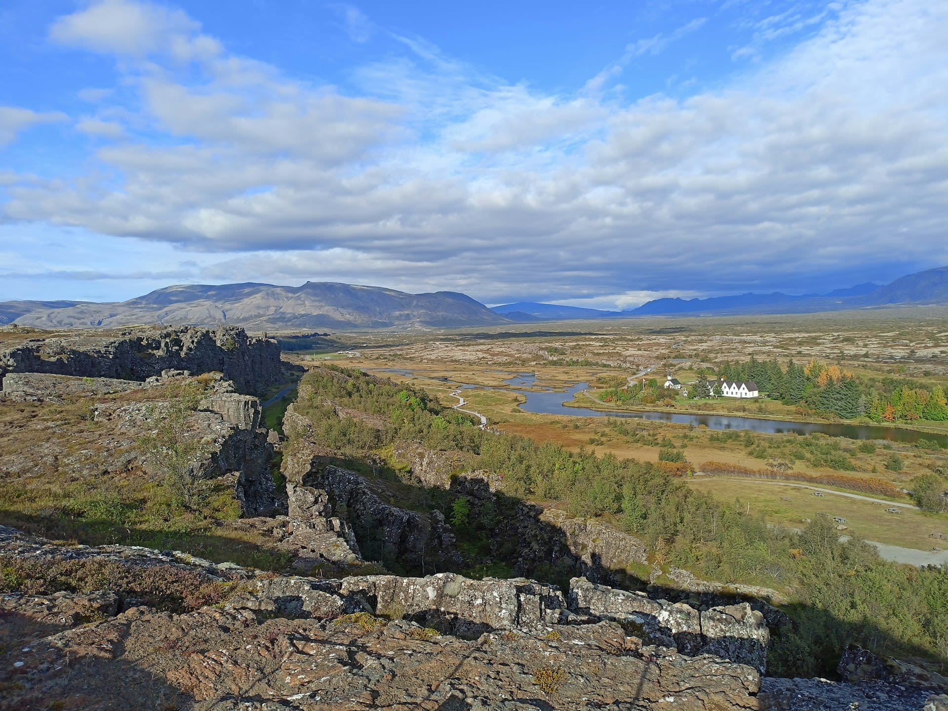
The Golden Circle is Iceland's most celebrated touring route, a roughly 300-kilometre loop from Reykjavík through the southwest highlands that encompasses three of the country's most significant landscapes: Þingvellir National Park (a UNESCO World Heritage Site and the birthplace of Icelandic democracy), the Geysir geothermal area (home of Strokkur, which erupts to 30 metres every 5–8 minutes and gave the English language the word 'geyser'), and Gullfoss waterfall (a 32-metre double cascade that ranks among the most powerful falls in Europe). The circuit can be driven in a single long day, but its geological and historical density rewards a two-day exploration. Þingvellir alone sits on the visible surface of the Mid-Atlantic Ridge, where the North American and Eurasian tectonic plates are physically diverging at 2.5 cm per year, making it one of the few places on Earth where the mechanics of plate tectonics can be seen, touched, and snorkelled.
🌍 Geography and Ecosystem
- Almannagjá Rift Gorge: A 7.7-km long fissure marking the eastern fault of the Mid-Atlantic Ridge rift, with vertical basalt walls up to 32 metres high. Walking through the gorge is walking between two continents — the western wall is North American plate, the eastern wall Eurasian. The canyon was also the site of executions in the Alþingi era, with criminals drowned in Drekkingarhylur pool at the northern end.
- Strokkur Geyser: The most reliably active geyser in Iceland, erupting every 5–8 minutes to heights of 15–40 metres. The eruption mechanism — a constriction in the conduit at approximately 23 metres depth that allows superheated water to flash explosively to steam — has been active continuously since a 1789 earthquake unblocked the vent. The original Great Geysir (from which all geysers take their name) is 60 metres wide but erupts only occasionally.
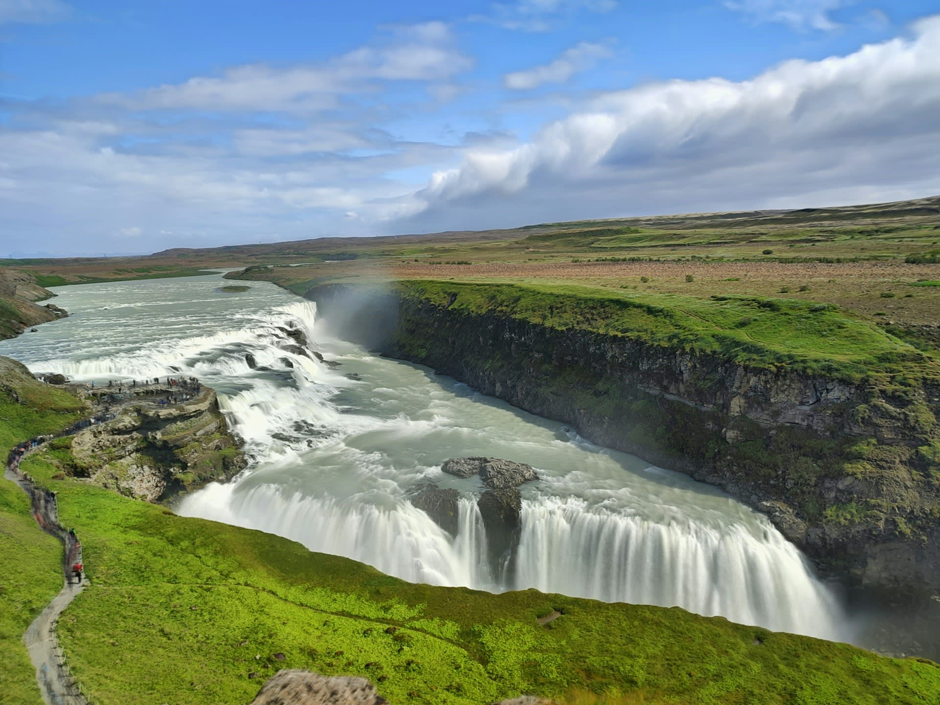
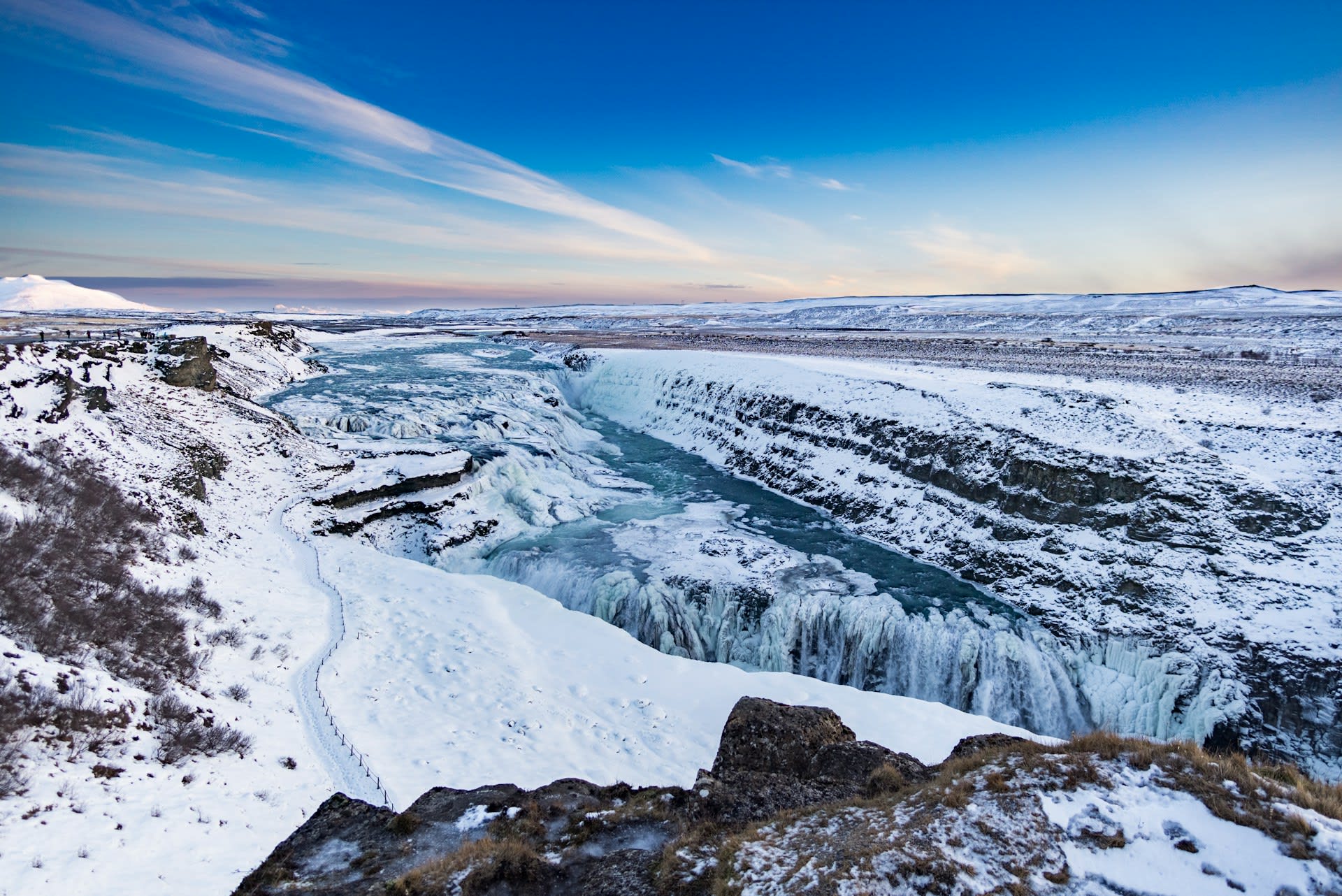
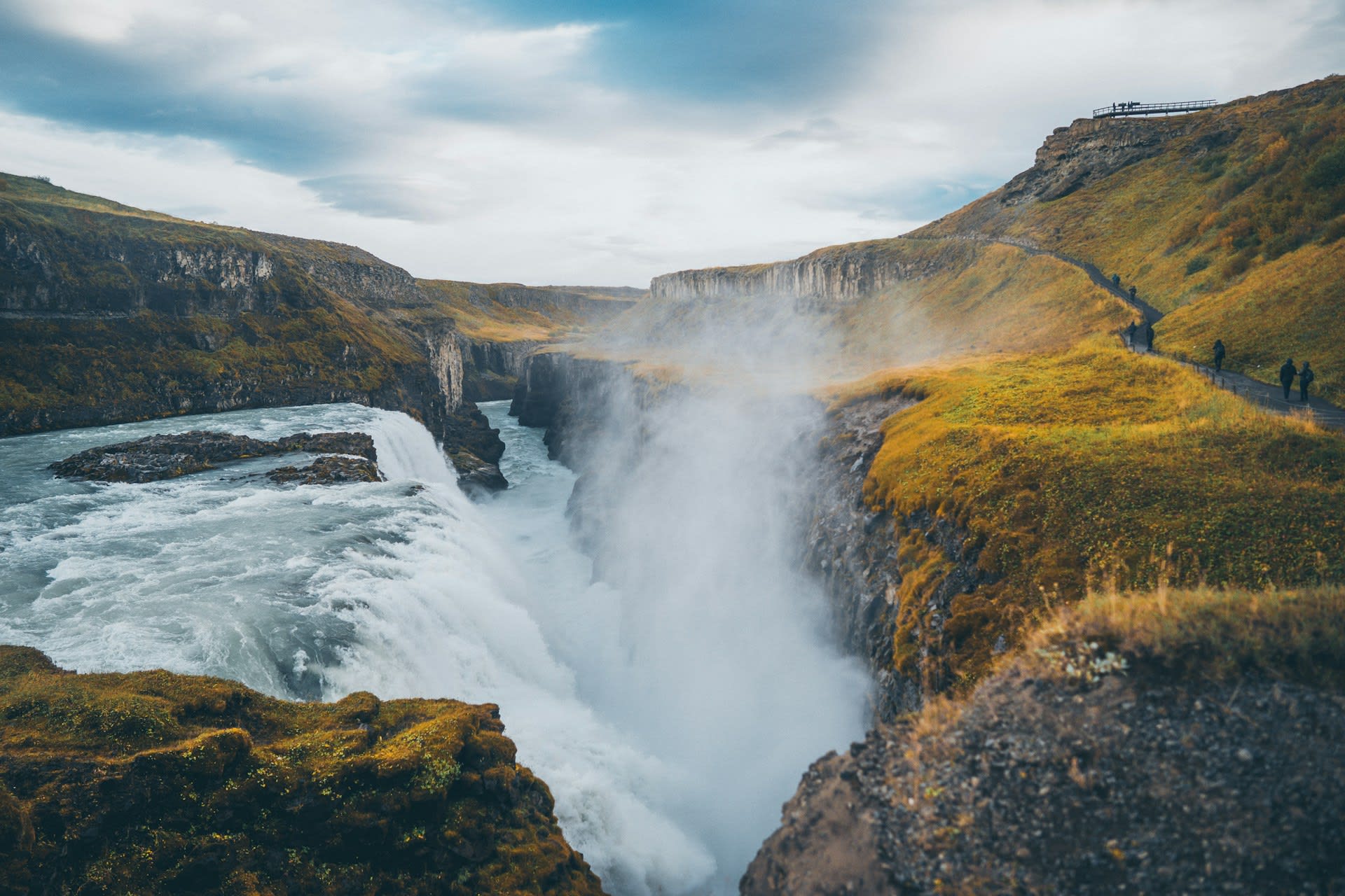
- Gullfoss Double Falls: The Hvítá River drops 11 metres in the first cascade and 21 metres in the second, oriented at right angles to each other so that the full force is visible only from specific viewpoints. Flow averages 140 m³/s but peaks at over 2,000 m³/s during spring snowmelt floods. Rainbow halos form in the spray on sunny days, and the falls are partially frozen in winter.
- Silfra Fissure: A submerged crack in the Þingvellir lakebed, formed by the diverging tectonic plates, filled with glacial meltwater filtered through lava rock for 30–100 years. The result is water of extraordinary clarity — visibility exceeds 100 metres — and a constant temperature of 2–4°C. Diving and snorkelling between the continental plates in Silfra is one of Iceland's most extraordinary adventure experiences.
📜 History and Cultural Significance
The Geysir geothermal area has been documented since at least the 13th century, and the Great Geysir was so famous in medieval Europe that it gave rise to the generic term 'geyser' — derived from the Old Norse verb gjósa (to gush). Several European royal expeditions visited the area in the 18th and 19th centuries, including a celebrated visit by King Frederick VII of Denmark in 1874. Gullfoss nearly met a different fate: in the 1920s, foreign investors proposed harnessing the waterfall for hydroelectric power, and the scheme was actively promoted by the Icelandic government. It was halted only through the campaigning of Sigríður Tómasdóttir, daughter of the local farmer who owned the land, who walked to Reykjavík repeatedly to protest and threatened to throw herself into the falls rather than permit their destruction. The legal challenge ultimately succeeded and Gullfoss was purchased by the Icelandic state and protected in 1979.
🏃 Activities and Attractions
- Snorkelling and Diving Silfra: The Silfra fissure at Þingvellir offers one of the world's most remarkable dive experiences — floating in 2°C water of 100-metre visibility between the continental plates, with electric-blue and green algae and lava formations visible in extraordinary detail. Guided tours depart daily from the Silfra carpark; PADI open water certification required for diving, none for the snorkelling tour (drysuits provided).
- Geysir Geyser Watching: Strokkur erupts so reliably — every 5–8 minutes — that visitors can time their photographs to the second. Staying for multiple eruptions allows observation of the different eruption heights (15–40 m) produced by varying underground pressure. The surrounding area contains over 30 smaller hot springs and mud pools, all viewable on a 20-minute self-guided walk.
- Gullfoss Winter Visit: In winter (December–March), the falls are partially ice-encrusted, creating formations of frozen spray on the canyon walls and a dramatic contrast of white ice, dark basalt, and thundering water. Ice conditions occasionally allow visitors to approach closer than summer safety barriers permit. The viewpoints are accessible year-round.
- Þingvellir Walking Trails: The national park maintains 50+ km of marked trails across the rift valley. The Almannagjá gorge walk (2.5 km one way) passes the Lögberg (Law Rock) where the Alþingi held its proceedings, the Drekkingarhylur drowning pool, and viewpoints onto Þingvallavatn. The Arnarvatn trail (7 km) climbs to an elevated plateau for sweeping views of the entire rift valley structure.
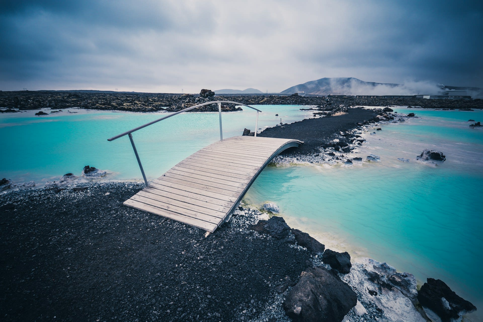
- Secret Lagoon Detour: Near the village of Flúðir, 20 minutes south of the Geysir area, the Gamla Laugin (Secret Lagoon) is Iceland's oldest public swimming pool (1891), a naturally heated geothermal pool at 38–40°C surrounded by hot springs and small geysers. Far less crowded and commercialised than the Blue Lagoon, it provides an authentic rural Icelandic bathing experience for a fraction of the cost.
💡 Travel Tips
Best Season: Year-round accessibility (Route 35 is kept open in winter). Summer (June–August) provides midnight sun and best weather. Winter (November–February) offers aurora possibilities, snow-covered landscapes, and Gullfoss partially frozen. The shoulder seasons (April–May, September–October) balance good light with lower visitor numbers.
Combining with Other Routes: The Golden Circle pairs naturally with the Reykjanes Peninsula (Blue Lagoon) as a 2-day southwest Iceland itinerary. Adding the Snæfellsnes Peninsula to the west creates a 3-day loop covering Iceland's most iconic non-volcanic destinations.
Accommodation: Flúðir village and Selfoss town offer accommodation close to the Golden Circle for overnight stays. The ION Adventure Hotel near Þingvellir provides extraordinary aurora viewing from geothermal hot tubs. Book all accommodation a minimum of 2 months in advance for summer visits.
🌱 Conservation
The Geysir area is protected under the Geysir Nature Reserve designation, which prohibits any interference with the hydrothermal system. Historically, visitors attempted to trigger Great Geysir eruptions by throwing rocks, soap, and other materials into the vent — practices that clogged the conduit and contributed to the geyser's current dormancy. The current management regime prohibits all objects being thrown into any geothermal feature. At Gullfoss, the path to the upper viewpoint was extended in 2021 to reduce erosion on the most heavily trafficked section of cliff edge, and visitor numbers to the spray-zone below the falls are managed through timed access during peak season.