


Corsica
Corsica (Corse) is a French island of 8,680 km² in the central Mediterranean — 180 km north of Sardinia, 90 km west of the Italian Riviera — combining, at remarkable density, some of the finest beaches in the Mediterranean, the highest mountain peaks south of the Alps on an island (Monte Cinto, 2,706 m), 3,000 km² of the maquis (the dense aromatic scrubland of granite hillsides that perfumes the island from February to June), two active UNESCO Biosphere Reserves, and the longest and toughest long-distance mountain trail in Europe — the GR20. Called l'Île de Beauté (the Isle of Beauty) since at least the 18th century, Corsica has been preserved from the over-development that has compromised comparable Mediterranean islands partly by its rugged terrain and partly by the fierce cultural independence of its population, which resisted Genoese, French, and general tourism homogenisation with an effectiveness unmatched in the Mediterranean. Two-thirds of the island is protected as the Parc Naturel Régional de Corse. The island's natural diversity — from subalpine granite lakes at 2,000 m to coral reefs at sea level — is extraordinary for its size.
🌍 Geography and Ecosystem
- GR20 Trail: The GR20 is Europe's most demanding long-distance trail — 180 km crossing the Corsican central mountains from Calenzana in the northwest to Conca in the southeast, spending 15 days above 1,500 m with multiple sections above 2,000 m on exposed granite ridges. The trail traverses the entire ecological gradient of the island — from Atlantic-facing maquis through Laricio pine forest and subalpine meadow to bare granite summit zones — and is widely regarded as the finest mountain trail in Europe for combined scenery, challenge, and remoteness. Annual completions average 12,000–15,000.
- Bonifatu and Niolu Forests: The Forêt de Valdo-Niello and Forêt d'Aïtone are the finest old-growth forests in Corsica — stands of Laricio pine (Pinus nigra laricio), the tallest native tree in France (reaching 50 m), mixed with beech, oak, and chestnut. These forests were spared the deforestation that affected much of the Mediterranean basin due to their remoteness and the granite terrain that made exploitation difficult. The Laricio pine forests around Col de Vergio (1,477 m) are the most accessible, threaded by hiking trails from the D84 road.
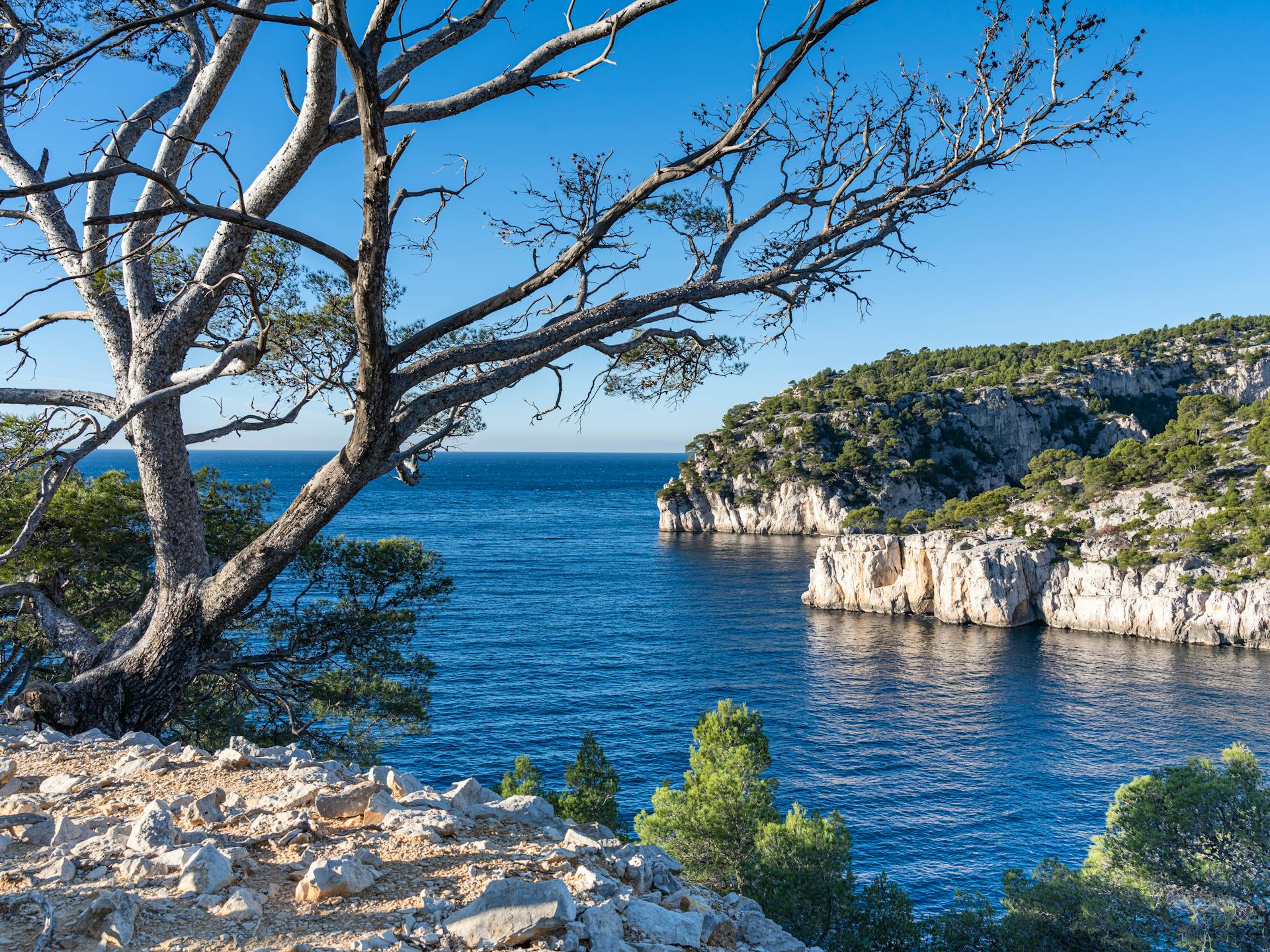
- Calanques de Piana: The Calanques de Piana — an UNESCO World Heritage site on the western coast — are a landscape of eroded red and orange granite formations rising directly from the sea, creating an abstract sculpture park of pillars, arches, and chasms above the blue Gulf of Porto. The D81 coastal road through the calanques is one of the most spectacular Mediterranean coastal drives. Sea kayaking and boat tours access the sea-level granite formations from Porto village.
- Marine Reserves: Corsica's marine environment — particularly the Réserve Naturelle des Bouches de Bonifacio at the southern tip — contains some of the finest coral and posidonia (seagrass) ecosystems in the Mediterranean. The clear, cold water upwelling around the southern cape supports exceptional underwater visibility (30+ m in summer) and a recovering marine ecosystem including grouper, dentex, and octopus populations. The reserve's strict no-fishing zones have produced measurable fish biomass recovery since their creation in 1999.
📜 History and Cultural Significance
The island's language — Corsu, a Romance language closely related to Tuscan Italian — has been maintained despite French cultural dominance and is still spoken by a significant minority. The island's distinctive polyphonic vocal tradition (paghjelle) — multi-part male vocal harmonics performed at festivals and religious celebrations — was inscribed on the UNESCO Intangible Cultural Heritage list in 2009. The Corsican nationalist movement, active from the 1970s and largely pacified since 2014, was instrumental in preserving the island from the scale of development that transformed Sardinia and the Balearics — an unintended conservation benefit of political resistance to outside investment.
🏃 Activities and Attractions
- GR20 Hiking: Hiking sections of the GR20 — even without completing the full 15-day route — provides access to the finest mountain scenery in the Mediterranean. The northern section (Calenzana to Vizzavona, 9 stages) is more dramatic and technical; the southern section (Vizzavona to Conca, 7 stages) is more varied and less frequented. Popular entry points for non-GR20 hikers include the Lac de Nino loop (from Albertacce), the Cirque de la Solitude section via Bocca Minuta (very exposed scrambling), and the Monte Cinto summit approach from Haut-Asco.
- Beach and Sea: The Golfe de Porto-Vecchio in the southeast — with beaches like Santa Giulia and Palombaggia — and the Golfe de Valinco and Désert des Agriates coast in the north are the finest beach landscapes, combining turquoise Mediterranean water with white granite or quartz sand. Snorkelling in the Bouches de Bonifacio marine reserve is accessible from the beaches of Lavezzi islands. The water temperature (22–26°C July–September) and visibility make Corsica one of Europe's finest snorkelling destinations without specialist equipment.
- Gorges du Tavignano and Canyon Swimming: Several of Corsica's mountain rivers create spectacular gorge landscapes accessible by swimming — particularly the Gorges du Tavignano (accessible from Corte) and the Gorges de la Restonica (which lead up to the subalpine lakes Lago Melo and Lago Capitello). The Restonica valley is the most visited interior valley, accessible by road to a car park at 1,370 m and then on foot to the glacier-carved lakes at 1,700–2,000 m — among the clearest and coldest mountain lakes in the Mediterranean.
- Bonifacio: The citadel town of Bonifacio at the island's southern tip is built entirely on a white limestone promontory undercut by sea erosion — with medieval Genoese buildings overhanging 60 m cliffs above the sea strait. The combination of the geological drama, the medieval town, and the Bouches de Bonifacio marine reserve below makes it the most scenically concentrated point on the island. Sea caves below the cliffs accessible by kayak include the Grotte du Sdragonato — a sea cave whose roof crack illuminates the floor in the shape of Corsica on certain tidal conditions.
💡 Travel Tips
Best Season: May–June is the finest period — the maquis is in full fragrant bloom, sea temperature is warming, and accommodation is not yet at capacity. September–October offers warm sea (still 22–24°C), clear mountain air, and departed summer crowds. July–August is peak season — roads, beaches, and GR20 huts are at maximum capacity, booking all accommodation months in advance is essential. April and November are shoulder seasons: mountain trails have snow at elevation in April, but the island is spectacularly beautiful and empty.
GR20 Logistics: GR20 refuges (staffed mountain huts) must be booked in advance through the PNRC Corsica reservation system (parc-corse.org). The trail runs from mid-June to mid-October; July–August is maximum crowding. Many hikers send luggage between valley villages by taxi to reduce load on the most difficult sections.
🌱 Conservation
The main conservation challenges are wildfire — the dry maquis burns intensely in summer, with major fires destroying thousands of hectares in dry years — and coastal development pressure. Corsica's building laws are among the strictest in France (no construction within 100 m of the shoreline) but enforcement has been inconsistent, and illegal construction on coastal land has been a persistent issue. The Conservatoire du Littoral has acquired significant stretches of Corsican coastline for permanent protection, including the entire Désert des Agriates coast — now one of the longest unspoiled coastlines in the Mediterranean. Climate change is extending the fire season and shifting the vegetation zones upward — Laricio pine forests are increasingly stressed by summer drought, and the maquis is expanding at the expense of the pine forest in the lower mountain zones.