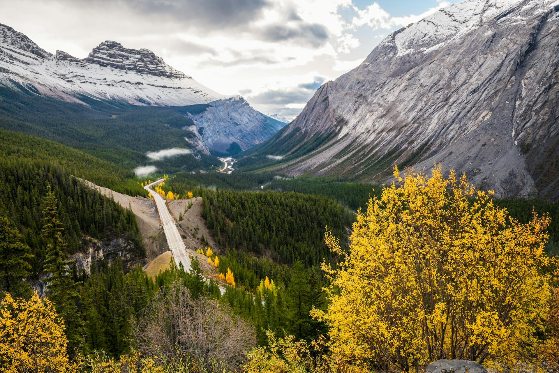
Icefields Parkway
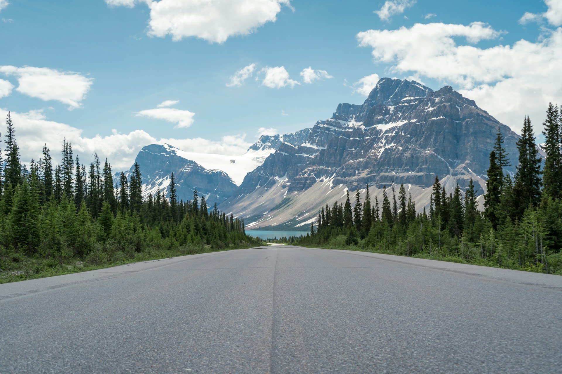
The Icefields Parkway (Highway 93) is a 232 km mountain highway in Alberta, Canada, running through the heart of the Canadian Rockies from Lake Louise in Banff National Park north to Jasper townsite in Jasper National Park. Completed in 1940, it traverses some of the most visually dramatic mountain terrain on Earth — a continuous corridor of glaciers, icefields, turquoise glacial lakes, waterfalls, and limestone peaks exceeding 3,000 metres. The route passes the Columbia Icefield, one of the largest accumulations of ice south of the Arctic Circle at 325 km², and the source of rivers draining to three different oceans. Iconic viewpoints along the route include Peyto Lake — whose wolf-head shape and impossible turquoise colour have made it one of Canada's most photographed landscapes — and Athabasca Falls, where the entire Athabasca River thunders through a narrow quartzite canyon. Wildlife is abundant and approachable: grizzly bear, black bear, moose, elk, mountain goat, bighorn sheep, and wolverine are all regularly sighted from or near the road. The parkway corridor is designated a UNESCO World Heritage Site as part of the Canadian Rocky Mountain Parks.
🌍 Geography and Ecosystem
- Columbia Icefield: The largest icefield in the Rocky Mountains, spanning 325 km² at elevations of 1,900–3,400 m. The icefield feeds six major glaciers including the Athabasca Glacier, which descends to within 300 m of the highway and is accessible on guided ice walks. Meltwater from the Columbia Icefield drains to the Pacific Ocean via the Columbia River, to Hudson Bay via the North Saskatchewan River, and to the Arctic Ocean via the Athabasca and Mackenzie rivers — one of only three hydrological apexes in the world draining to three oceans.
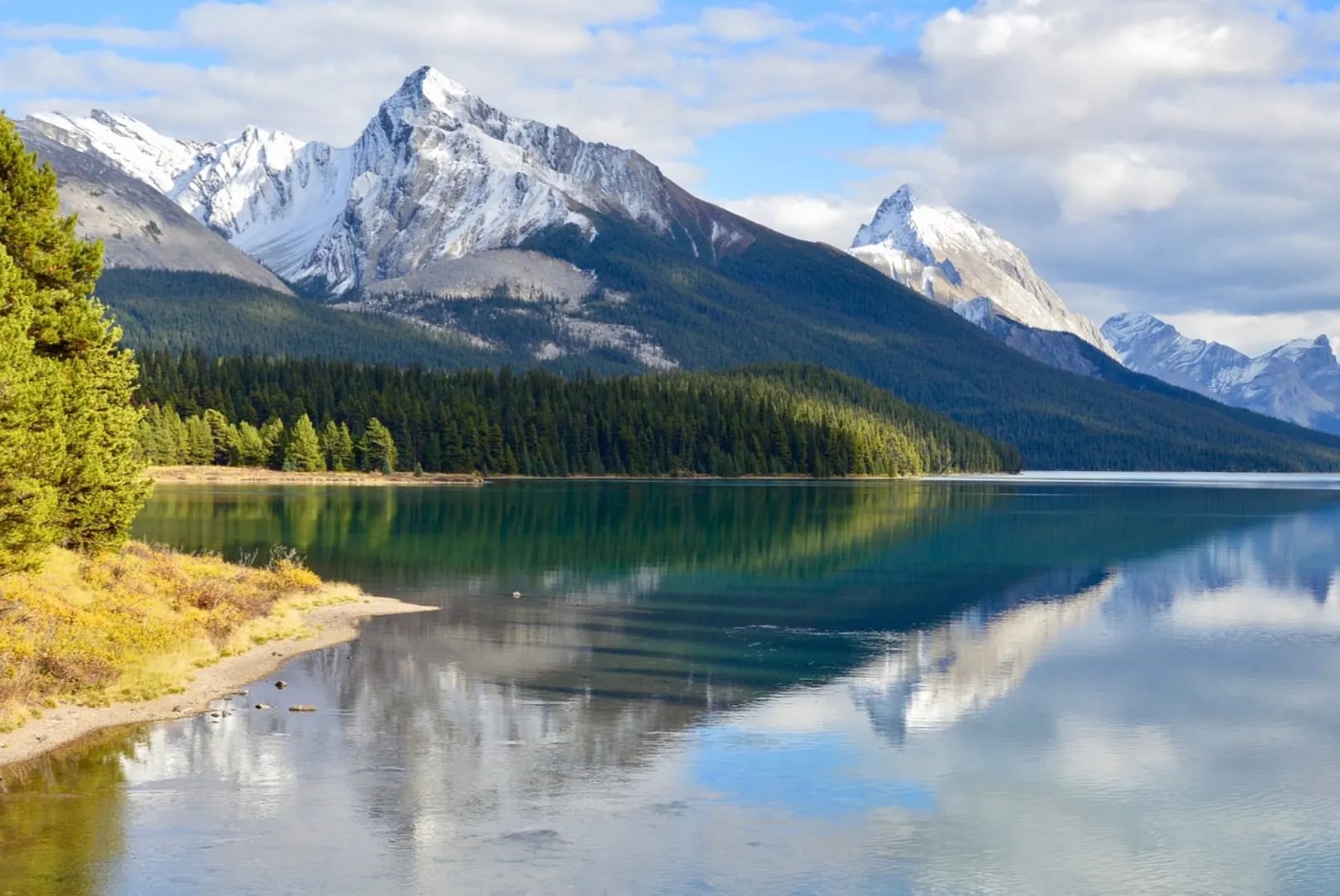
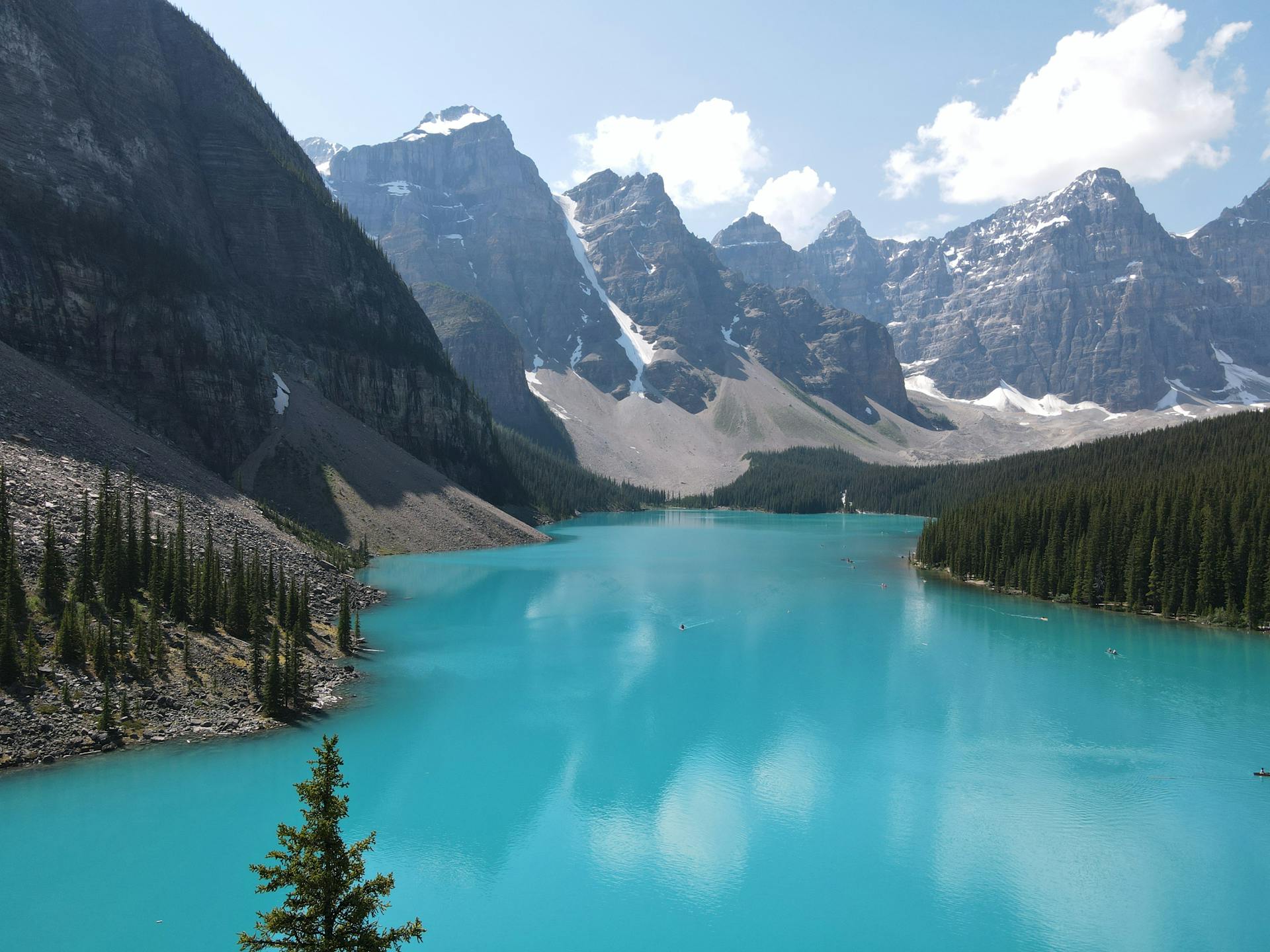
- Glacial Lakes: The Rockies' most celebrated lakes — Peyto, Bow, Hector, Waterfowl, Mistaya — owe their extraordinary turquoise and cyan colours to glacial rock flour: fine particles of pulverized rock suspended in meltwater that scatter short-wavelength blue and green light. The colour intensity changes with season — deepest in July–August when glacial melt is greatest, more subdued in spring and autumn.
- Montane and Subalpine Ecosystems: The valley floors support montane forest of lodgepole pine, Engelmann spruce, and subalpine fir, transitioning to open subalpine meadows of heather and wildflowers above treeline (2,200 m). Larches — the only deciduous conifers in the Rockies — turn a brilliant gold in late September and October around Larch Valley and the Parker Ridge area, creating autumn colour displays comparable to the best in North America.
- Parker Ridge and Wilcox Pass: Two of the parkway's finest short hikes access high alpine terrain above treeline. Parker Ridge (2 km, 250 m ascent) tops out on a ridge above the Saskatchewan Glacier, the longest tongue of the Columbia Icefield. Wilcox Pass (4 km, 335 m ascent) was the original route used by outfitters before the road was built and delivers panoramic views of the Athabasca Glacier and the Sunwapta Valley from above.
📜 History and Cultural Significance
The parkway itself was constructed as a Depression-era relief project employing unemployed men at $0.20 per day through the 1930s, completed in 1940. Banff (1885) and Jasper (1907) national parks were among Canada's first protected areas, established primarily to protect the scenery and tourism potential of the railway corridor. The Canadian Rocky Mountain Parks were inscribed as a UNESCO World Heritage Site in 1984, extended in 1990 to encompass 20,160 km² — one of the largest World Heritage landscapes in North America.
🏃 Activities and Attractions
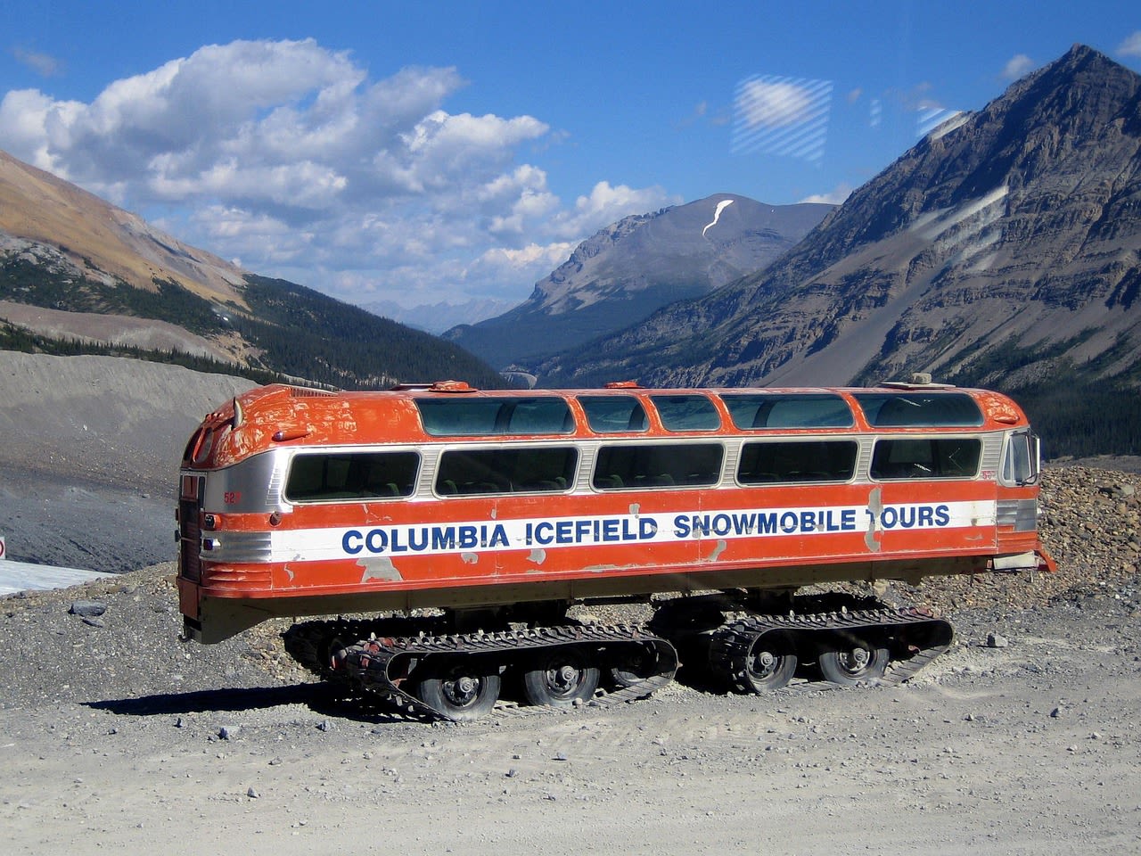
- Athabasca Glacier Ice Walk: The Columbia Icefield Adventure centre at the parkway's midpoint offers guided walks onto the Athabasca Glacier surface — crossing crevasse zones and exploring glacial features under the guidance of certified glacier guides. The glacier's edge is accessible by Ice Explorer snow vehicle (a modified bus with enormous tyres) to a flat ice plain, with guided foot walks beyond. The experience of standing on continental ice in midsummer with a limestone mountain backdrop is elemental.
- Peyto Lake Overlook: A 1 km paved trail from the Bow Summit parking area (the highest point on the Icefields Parkway at 2,069 m) reaches the most photographed viewpoint in the Canadian Rockies: a wolf-head-shaped turquoise lake 400 m below, framed by the Mistaya Valley and the peaks of the Waputik Range. The colour is most intense in July and August. The same area accesses the Bow Summit Ridge for extended views north toward Jasper.
- Wildlife Watching: The parkway is one of the best wildlife corridors in North America for roadside wildlife viewing. Black bears and grizzly bears are regularly seen foraging on slopes above the road in spring and autumn. Moose wade in marshy lakes near Waterfowl Lakes. Mountain goats are reliable at Goats and Glaciers viewpoint south of Jasper. Bighorn sheep often stand on the road itself. Wolves occasionally cross the road in morning or evening. Dawn and dusk drives yield the most sightings.
- Skywalk: The Glacier Skywalk, 4 km from the Icefield Centre, is a glass-floored observation platform cantilevered 280 m above the Sunwapta Valley floor — offering a vertiginous view of the valley, glacier, and surrounding peaks for those who can tolerate glass-floor exposure. A guided walk along the cliff-edge boardwalk provides interpretation of the geology and ecology of the area from a unique perspective.
- Winter Driving and Ice Climbing: The parkway is maintained year-round and is dramatic in winter — snow-laden forest, frozen waterfalls, and crisp mountain air. Weeping Wall on the north side of Cirrus Mountain freezes into a spectacular multi-pitch ice climbing venue (grade WI3–WI4) accessible from the road and one of the most accessed ice climbing venues in Canada. Winter photography on the parkway, with blue ice, frost-rimed forest, and aurora possibilities, is exceptional.
💡 Travel Tips
Best Season: June–September is the core season when all facilities are open and the glacial lakes are at their most colourful. July and August are peak crowds — parking lots at Peyto Lake and Athabasca Glacier fill by 9am in midsummer; arrive early or late. Late September brings larch colour and dramatically reduced crowds. October–May the parkway is driveable but many services close, temperatures are cold, and snowstorms can close passes with little warning.
Accommodation: Jasper townsite and Lake Louise village anchor each end of the parkway with hotels, hostels, and camping. Along the route: Num-Ti-Jah Lodge at Bow Lake (historic 1920s lodge), The Crossing resort at Saskatchewan River Crossing (the only services at the parkway's midpoint), and Parks Canada campgrounds at Waterfowl Lakes, Columbia Icefield, and Wilcox Creek. Booking months in advance is essential July–August.
🌱 Conservation
Wildlife management on the parkway addresses the fundamental tension between the road's value as a wildlife corridor (which requires low-permeability barriers to remain open) and visitor pressure that can disrupt animal movement and habituate wildlife to humans. Parks Canada manages this through traffic controls, wildlife hotspot closures during denning and rearing seasons, and wildlife crossing structures (underpasses and overpasses) at key locations. The Trans-Canada Highway wildlife crossing program — which has dramatically reduced wildlife-vehicle collisions in Banff — is being evaluated for potential extension to parkway pinch points. Visitor capacity management is an increasing priority as annual parkway traffic has grown beyond infrastructure designed for a fraction of current numbers.