Cape Breton Highlands
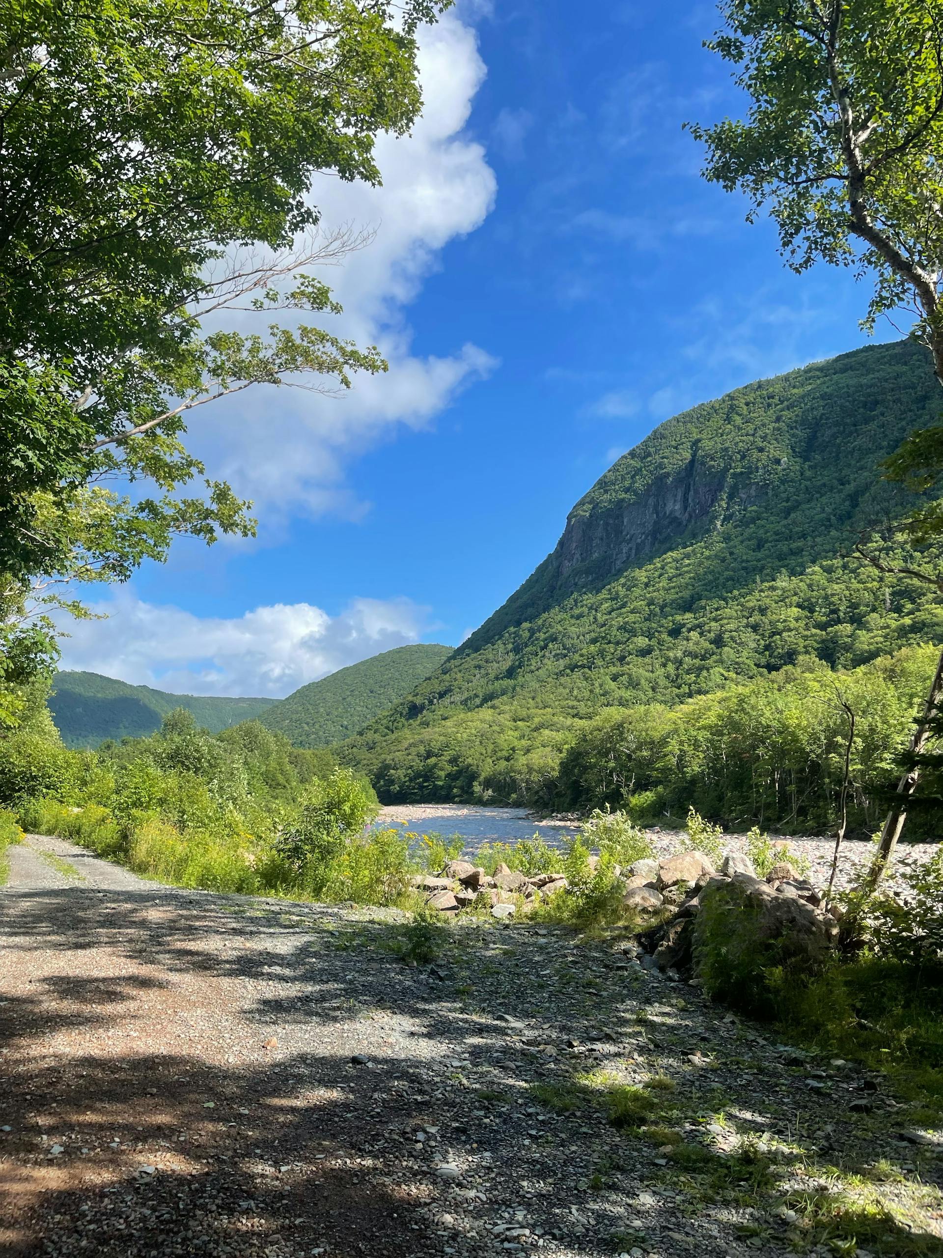
Cape Breton Highlands National Park encompasses 950 km² of the northern tip of Cape Breton Island, Nova Scotia — a dramatic landscape where a boreal plateau of ancient metamorphic rock drops abruptly to the sea in cliffs of 300–400 metres, and river valleys carved deep into the upland create some of the most spectacular gorge scenery in eastern North America. The park is bisected by the Cabot Trail, a 298 km scenic highway repeatedly ranked among the world's greatest drives — threading coastal cliff roads above the Gulf of St Lawrence on the west and the Atlantic Ocean on the east before climbing to the plateau interior. The natural environment is a blend of the Acadian forest (mixed sugar maple, yellow birch, and beech that flames into extraordinary autumn colour) and the boreal plateau (black spruce, balsam fir, and open taiga) at higher elevations — a southern extension of the boreal biome more typical of Labrador and northern Quebec. Moose are conspicuous throughout; the park has one of the densest moose populations in North America, introduced in the 1940s and now so numerous that their browsing has transformed the forest structure. The park was established in 1936 as Canada's first national park in the Maritimes.
🌍 Geography and Ecosystem
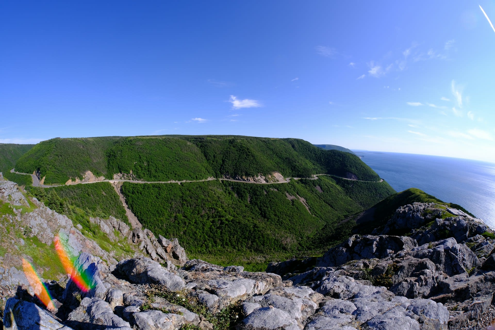
- Cabot Trail Coastal Drive: The western section of the Cabot Trail between Chéticamp and Pleasant Bay runs along a narrow coastal shelf between sheer cliff above and the Gulf of St Lawrence below — one of the most technically demanding and scenically spectacular sections of road in Canada. Pilot whales are regularly sighted from the clifftop viewpoints in summer, and the whale-watching from headlands like Fishing Cove is among the best accessible shore-based cetacean viewing in Atlantic Canada.
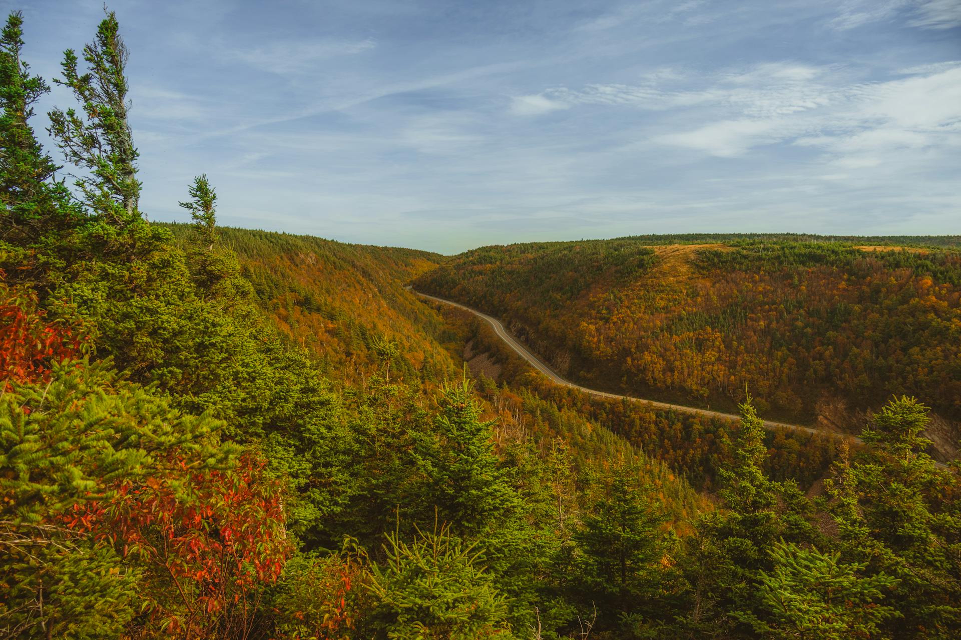
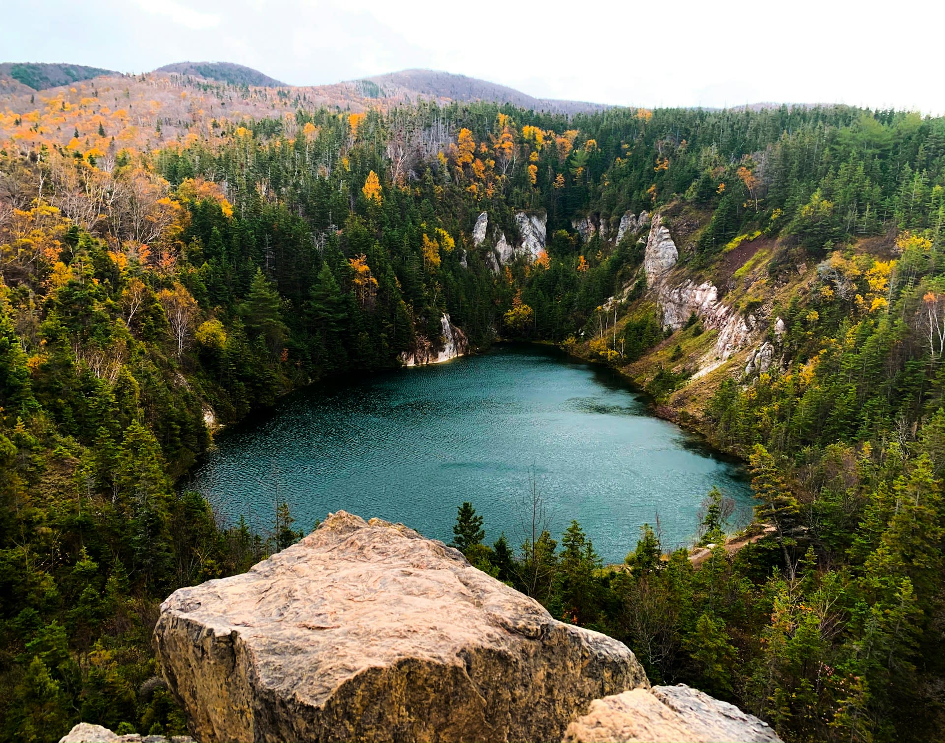
- Highlands Plateau Trails: The interior plateau is accessed by several backcountry hiking trails including the Skyline Trail (9.5 km loop), which crosses open boreal heath to a headland 300 m above the Gulf of St Lawrence — one of the most visited viewpoints in Atlantic Canada and a reliable location for moose sightings at dawn and dusk. The Aspy Trail accesses the Aspy River valley — the park's most spectacular river gorge — on the Atlantic side of the plateau.
- Keltic Lodge Headland: The headland at Ingonish on the Atlantic coast, where the park's eastern section meets the sea at the distinctive hourglass-shaped Ingonish Bay, offers a freshwater lake (Ingonish Lake) separated from salt water by a sand bar — an unusual combination where swimmers can choose fresh or salt water from the same beach. The Cape Smokey headland just south of the park boundary is the highest point of land directly above the Atlantic in Nova Scotia.
- Autumn Foliage: The Acadian forest of the lower slopes and valleys turns to exceptional autumn colour in late September–early October, when sugar maple, yellow birch, beech, and mountain ash create a mosaic of gold, orange, red, and scarlet against the dark conifer backdrop of the plateau. The combination of coastal light, highland elevation, and mixed-species forest makes Cape Breton one of eastern Canada's finest autumn colour destinations — less commercial than the Laurentides in Quebec but equally spectacular in peak years.
📜 History and Cultural Significance
The island became Scottish-Gaelic-speaking in the early 19th century as thousands of Highland Scots — displaced by the Clearances — settled the Cape Breton interior, creating an enduring Gaelic culture that persists in the Celtic music tradition of Cape Breton fiddling, recognised internationally as one of the world's most vital living folk traditions. The park's establishment in 1936 required the displacement of communities that had farmed and fished the Highland valleys for generations — a historical wound that continues to inform the relationship between the park and surrounding Acadian and Gaelic communities. The tension between conservation and community rights in the Cape Breton Highlands was a formative episode in Canadian national park history.
🏃 Activities and Attractions
- Skyline Trail: The park's most celebrated hike — a 9.5 km loop trail across open boreal heath to a clifftop headland 300 m above the Gulf of St Lawrence. The boardwalk-edged headland at trail's end offers panoramic views of the coastal cliffs in both directions, and the exposed heath crossing approaching the headland is the most reliable moose habitat in the park — moose are encountered on nearly every dawn or dusk hike. Evening visits in September–October are popular for moose and autumn colour simultaneously.
- Whale and Seabird Watching: The waters of the Gulf of St Lawrence off the western park boundary support significant cetacean populations. Pilot whales are abundant and frequently visible from clifftop viewpoints in July–September. Minke, fin, and humpback whales are regular offshore. Boat tours from Chéticamp and Pleasant Bay operate guided whale watching excursions through the summer. The same coastal waters host large colonies of razorbills, puffins, and gannets — the seabird diversity in the Gulf is among the highest in Atlantic Canada.
- Cabot Trail Drive: Driving the full Cabot Trail loop (298 km) over 2–3 days with stops at key viewpoints, beach access points, and the park interior is the core Cape Breton experience. Highlights include the cliffside coastal road between Chéticamp and Pleasant Bay (western), the plateau plateau crossing via the North Mountain access road (central), and the gentler Atlantic coast between Ingonish and Smokey. The drive is manageable year-round but requires care in winter when several sections are ice-prone.
- Celtic Music in Chéticamp and Inverness: The towns around the park — particularly Chéticamp (Acadian) and Inverness and Judique (Gaelic) — maintain an extraordinarily vital live music culture rooted in Celtic fiddle tradition. Celtic Colours International Festival in October transforms Cape Breton Island into one of the world's most concentrated folk music festivals, with concerts in churches, community halls, and outdoors throughout the island. Even outside festival season, Cape Breton kitchen parties and pub sessions continue year-round.
💡 Travel Tips
Best Season: July–August is peak season (busy, warm, full wildlife activity). Late September–early October is widely considered the finest time — autumn colour is spectacular, crowds thin dramatically after Labour Day, moose are active in rut, and the light is extraordinary. May–June is shoulder season — the park is beautiful but some services are not yet open. Winter sees the park largely empty; cross-country skiing on the Skyline plateau and snowshoeing are possible for winter visitors with appropriate equipment.
Accommodation: Chéticamp and Ingonish are the main accommodation hubs at the park's western and eastern entrances. Keltic Lodge (Parks Canada heritage property) at Ingonish is the grandest option. Camping within the park is excellent — Chéticamp, Broad Cove, Ingonish Beach, and MacIntosh Brook campgrounds cover the major access zones. Book Skyline Trail timed-entry permits (required July–August) online through Parks Canada reservation system.
🌱 Conservation
Parks Canada has been studying moose management options including controlled hunting, population reduction by culling, and wolf reintroduction — a contentious option given the island's small size and proximity to agricultural land. The park's forests also face threat from the balsam woolly adelgid, an introduced insect pest that kills balsam fir — currently expanding its range northward with warming temperatures. Climate change is expected to shift the boreal-Acadian forest boundary upward, progressively replacing boreal plateau vegetation with Acadian mixed forest and ultimately contracting the high-elevation boreal zone that defines the park's character. Long-term ecological monitoring programs coordinated with Dalhousie University track these changes across the plateau.