The Whitsundays
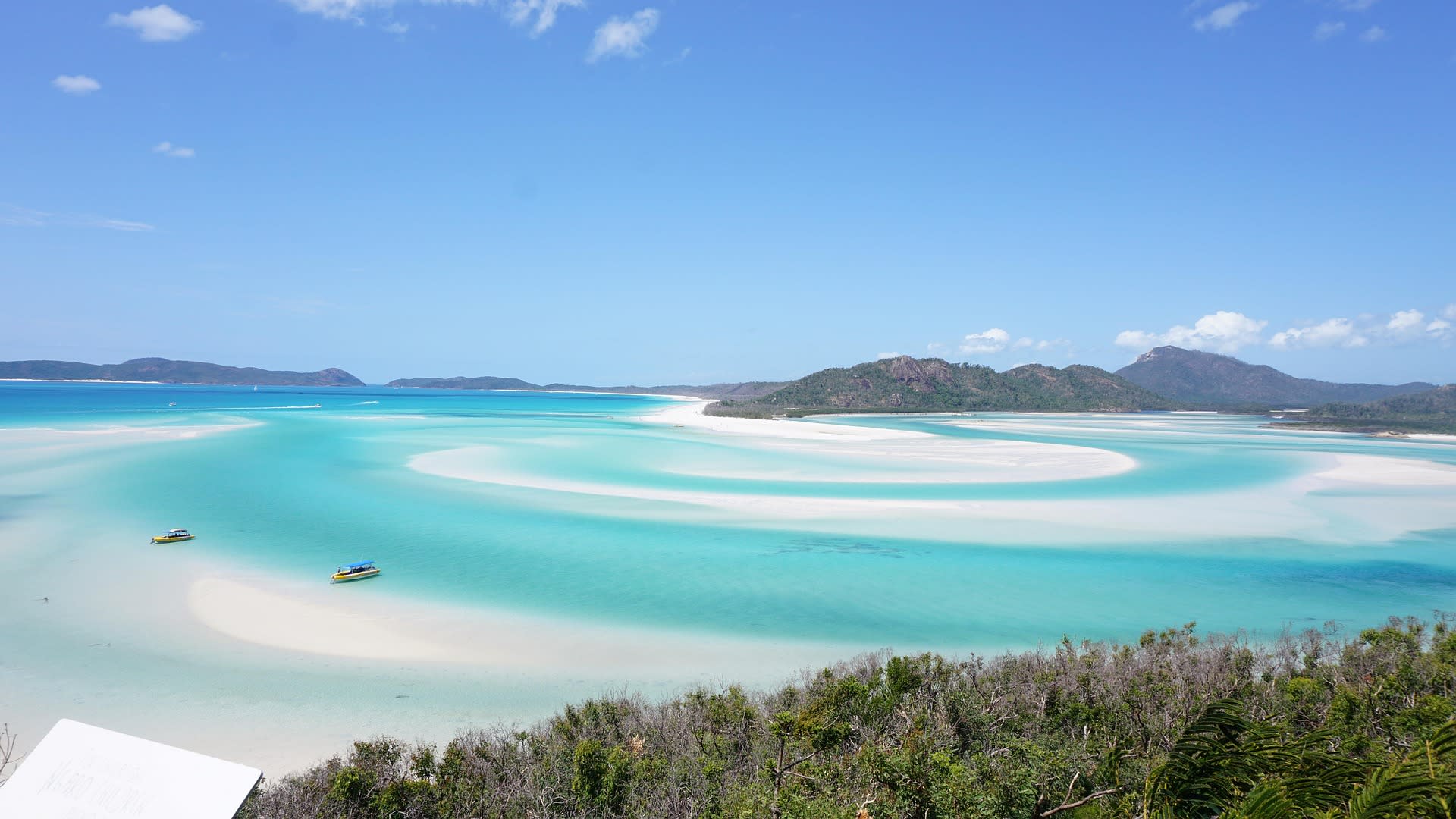
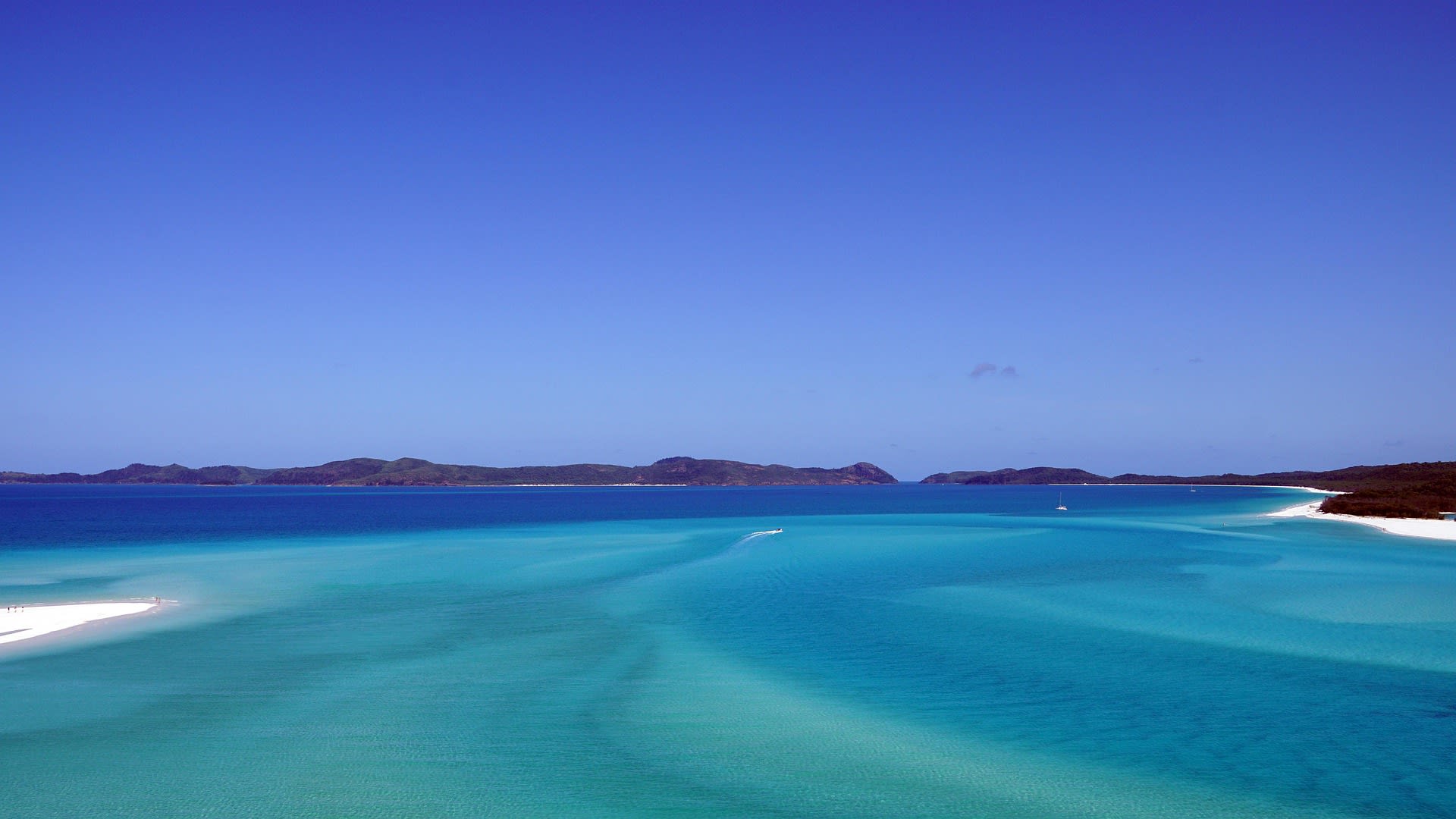
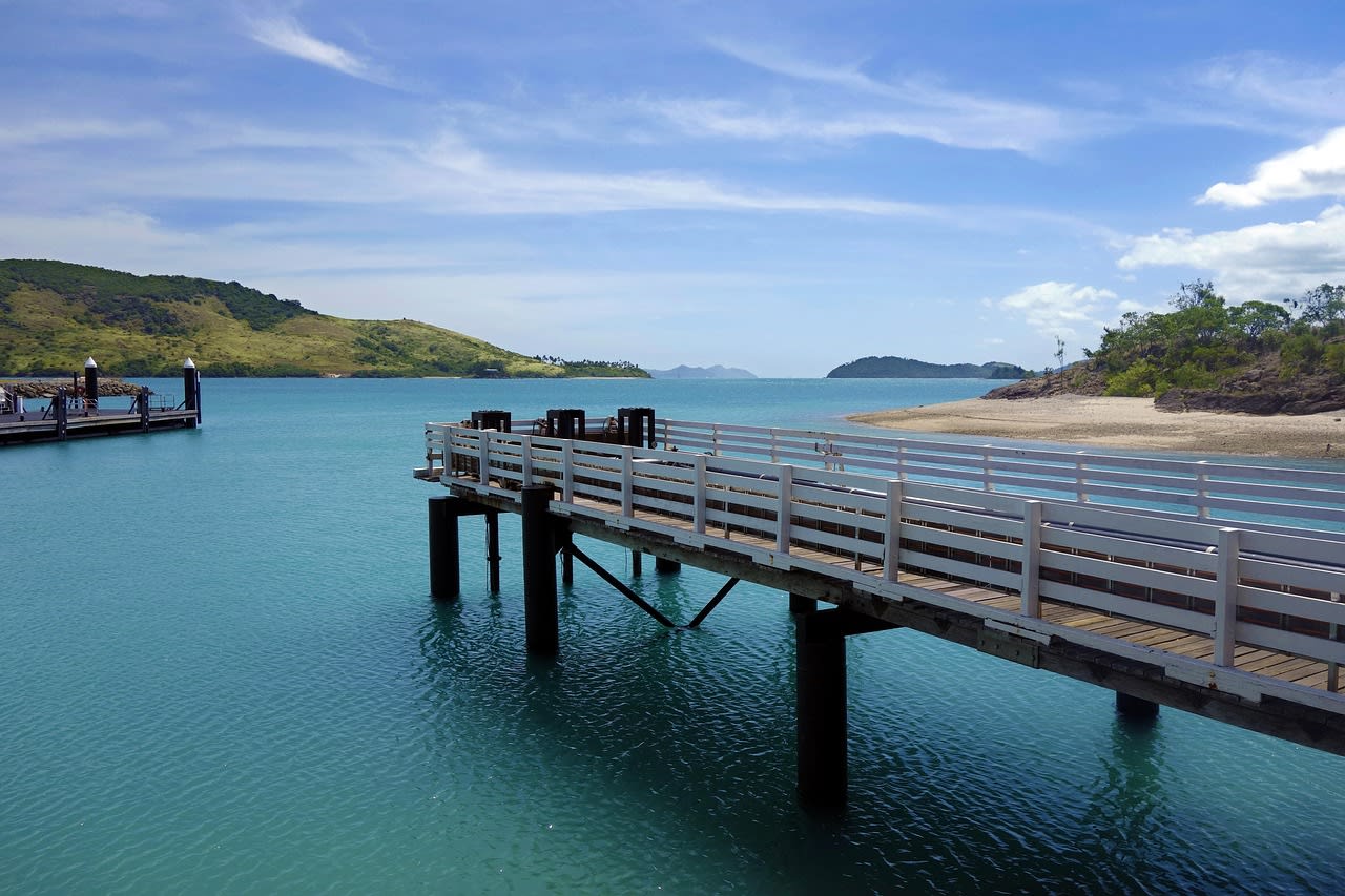
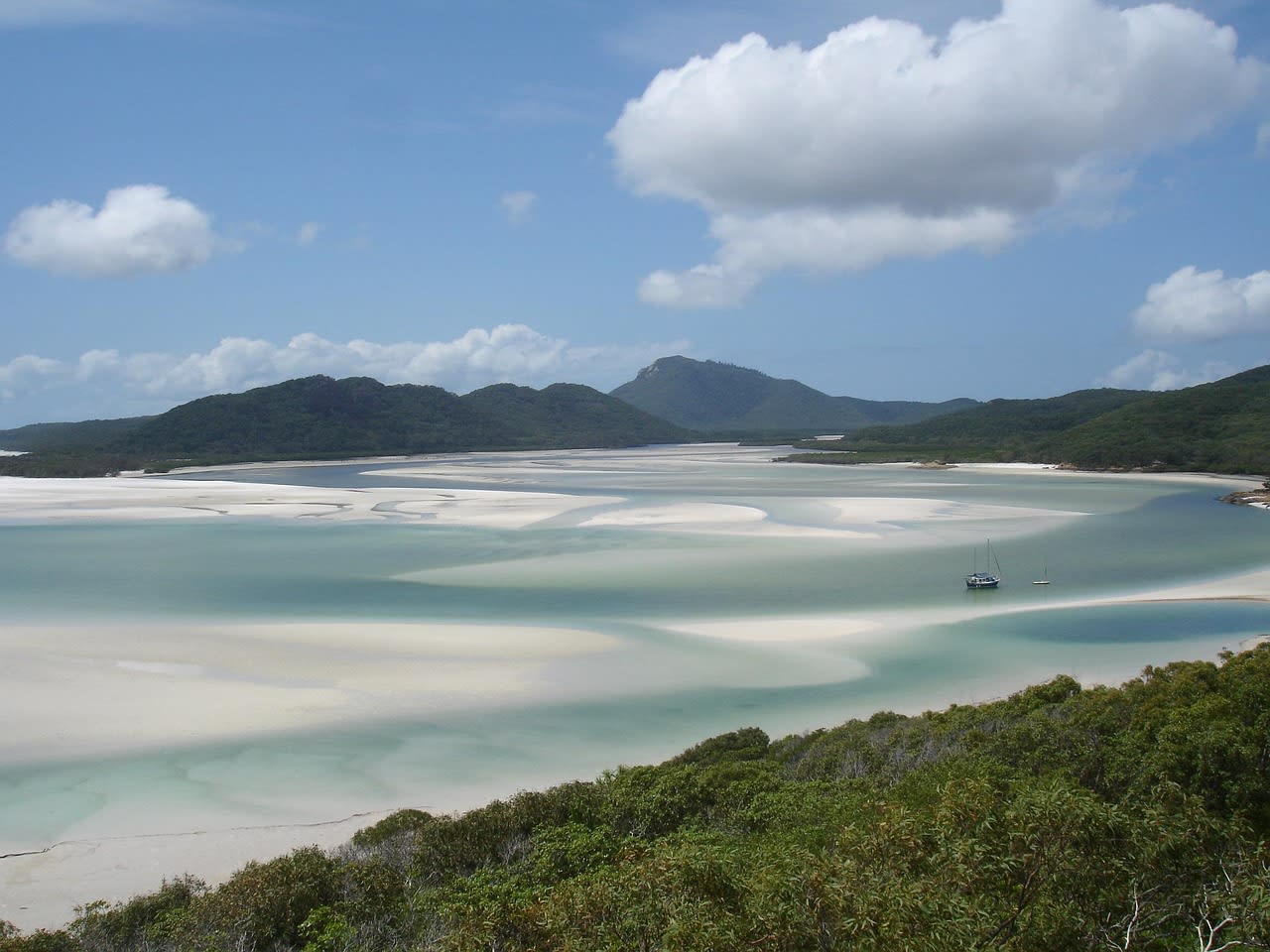
The Whitsunday Islands are an archipelago of 74 continental islands — the drowned peaks of a coastal mountain range — in the Coral Sea off the central Queensland coast, lying within the Great Barrier Reef Marine Park, the world's largest marine protected area. The islands are continental rather than coral cays: forested, hilly, and geologically ancient, rising to 438 m at the summit of Hook Island. They are surrounded by coral reefs, sea grass beds, and the extraordinary water clarity of the Coral Sea, which ranges from deep blue in the inter-island channels to the luminous turquoise of the reef flats. Whitehaven Beach on Whitsunday Island — accessible only by boat or seaplane — is composed of 98% pure silica sand, which is so fine and reflective that it remains cool to the touch even in direct sun and creates the swirling white-and-turquoise tidal patterns visible from the Hill Inlet lookout that have made it one of the most reproduced aerial photographs of any beach in the world. The island group is the centre of one of Australia's largest sailing and charter boat industries.
🌍 Geography and Ecosystem
- Whitehaven Beach and Hill Inlet: The 7 km beach on the western side of Whitsunday Island is composed entirely of silica sand eroded from the granite mountains of the Queensland ranges and carried north by longshore drift. The sand's 98% silica purity gives it exceptional whiteness and the unique property of not absorbing heat. At the northern end, Hill Inlet creates a tidal estuary where the incoming and outgoing tides swirl the white sand into constantly changing patterns in the turquoise water — an aerial view visible from the 15-minute walk to the Tongue Point lookout.
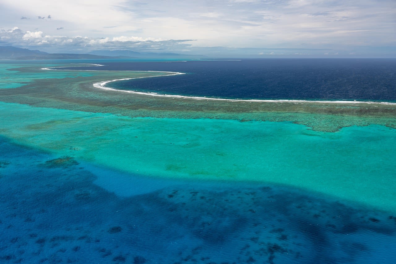
- Hardy Reef and Heart Reef: Hardy Reef, 65 km offshore from the islands, is the outer barrier reef section most accessible from the Whitsundays. A naturally occurring heart-shaped coral formation — Heart Reef — within Hardy Reef has become one of Australia's most iconic images. Access is by seaplane or helicopter (no swimming or snorkelling permitted on Heart Reef itself to protect the formation). The reef systems at Hardy and Hook Reef offer snorkelling and diving in coral gardens of high biodiversity.
- Hook Island Underwater Observatory: Hook Island, the second-largest in the group, has an underwater observatory in Nara Inlet accessible to non-divers — a structure descending 5 m below the surface with windows into coral bommies inhabited by fish schools, sea turtles, and giant clams. The island's interior walking tracks cross native eucalyptus and hoop pine forest where sea eagles nest and brush turkeys scratch through the leaf litter.
- Marine Wildlife: The Whitsundays passage is a major corridor for humpback whale migration — pods of humpbacks pass through the islands June–September, with whale watching boat tours operating from Airlie Beach regularly encountering whales at close range. Dugong — the Coral Sea's gentle sea grass grazers — are resident in the shallower channels around Repulse Bay and North Molle Island. Green and loggerhead sea turtles nest on several of the island beaches from October–February.
📜 History and Cultural Significance
James Cook sailed through the passage on Whit Sunday (the seventh Sunday after Easter) in 1770 and named the channel accordingly. He described the islands in his journal as 'the most beautiful I had ever seen' and named several prominent features. European settlement of the area was slow — the mainland town of Bowen was established in 1861, Airlie Beach much later in the 20th century. The Whitsundays became one of Australia's premier tourism destinations from the 1970s–80s with the development of resort islands including Hamilton Island (now one of Australia's largest island resorts), Hayman Island, and Daydream Island. The expansion of the charter boat industry transformed Airlie Beach from a small town to a major marine tourism hub.
🏃 Activities and Attractions
- Sailing Charter: A bareboat (self-skippered) or crewed sailing charter through the Whitsunday Islands — departing Airlie Beach or Hamilton Island, anchoring in coves on Hook, Hayman, and Whitsunday Islands, and swimming off the boat at anchor in turquoise water — is the archetypal Whitsundays experience. The wind pattern in the passage (SE trade winds April–October) is reliable and manageable for inexperienced sailors with a bareboat qualification. Multi-day charters of 3–7 days are standard.
- Whitehaven Beach Day Tour: Day boat tours from Airlie Beach and Hamilton Island carry visitors to Whitehaven Beach for 3–4 hours — including the Hill Inlet lookout walk (45 min return, extraordinary tidal views) and beach time on the silica sand. Seaplane tours offer the aerial perspective of the sand swirls at Hill Inlet that is the island's most iconic image. Whitehaven has no permanent facilities — no shops, cafes, or toilets — maintaining the pristine character that makes it remarkable.
- Snorkelling and Diving Hardy Reef: Full-day tours by fast catamaran from Airlie Beach reach Hardy and Hook Reef on the outer barrier for 2–3 hours of snorkelling and guided diving over coral gardens. Hardy Reef's Reefworld pontoon is moored permanently on the reef and provides changing facilities, an underwater observatory, and helicopter transfers from the mainland. The coral at Hardy Reef is in good condition relative to the bleaching-affected northern reef sections.
- Humpback Whale Watching: June–September whale watching tours from Airlie Beach and Hamilton Island encounter humpback whale pods migrating south through the passage — one of Queensland's most reliable whale watching windows. The passage geography concentrates the whales in relatively shallow channels where boat approach is straightforward. Encounters with mother-calf pairs are common; breaching and tail-slapping behaviour is regularly observed.
- Seaplane or Helicopter Scenic Flight: An aerial perspective of the Whitsundays — with the swirling Hill Inlet patterns, the reef patches in multiple shades of turquoise, and the island silhouettes against the Coral Sea — is one of Queensland's most spectacular scenic flight experiences. Several operators combine a scenic flight with a landing at Whitehaven Beach, maximising both the aerial and ground-level experience of the island group.
💡 Travel Tips
Best Season: April–October (dry season) for reliable southeast trade winds ideal for sailing, comfortable temperatures (22–28°C), and clear skies. June–September is peak humpback whale season. November–March is the wet season and cyclone season — higher humidity and risk of cyclones, but also the warmest water temperatures for swimming and the greening of the island forests. Box jellyfish are present in Queensland coastal waters October–May; swim inside stinger nets at resort beaches or wear a stinger suit when snorkelling.
Accommodation: Hamilton Island offers the widest range of island accommodation from hotel rooms to private villas. Airlie Beach on the mainland has the highest concentration of budget and mid-range accommodation — backpacker hostels, apartments, and hotels all within walking distance of the marina. Resort islands (Daydream, Hayman) offer luxury all-inclusive options. Camping is permitted on several islands (Whitsunday Island, Hook Island) with self-registration at National Parks kiosks.
🌱 Conservation
Cyclone Debbie (Category 4, March 2017) caused significant damage to both reef systems and island infrastructure, with Airlie Beach and several resort islands severely affected. Recovery has been substantial but the event highlighted the vulnerability of both ecological and tourism infrastructure to extreme weather. The Queensland government's Reef 2050 Long-Term Sustainability Plan commits to reducing agricultural runoff, managing crown-of-thorns starfish outbreaks, and limiting coastal development impacts, but the primary threat — ocean warming driven by global CO₂ emissions — lies outside any single government's control.