Sacred Valley
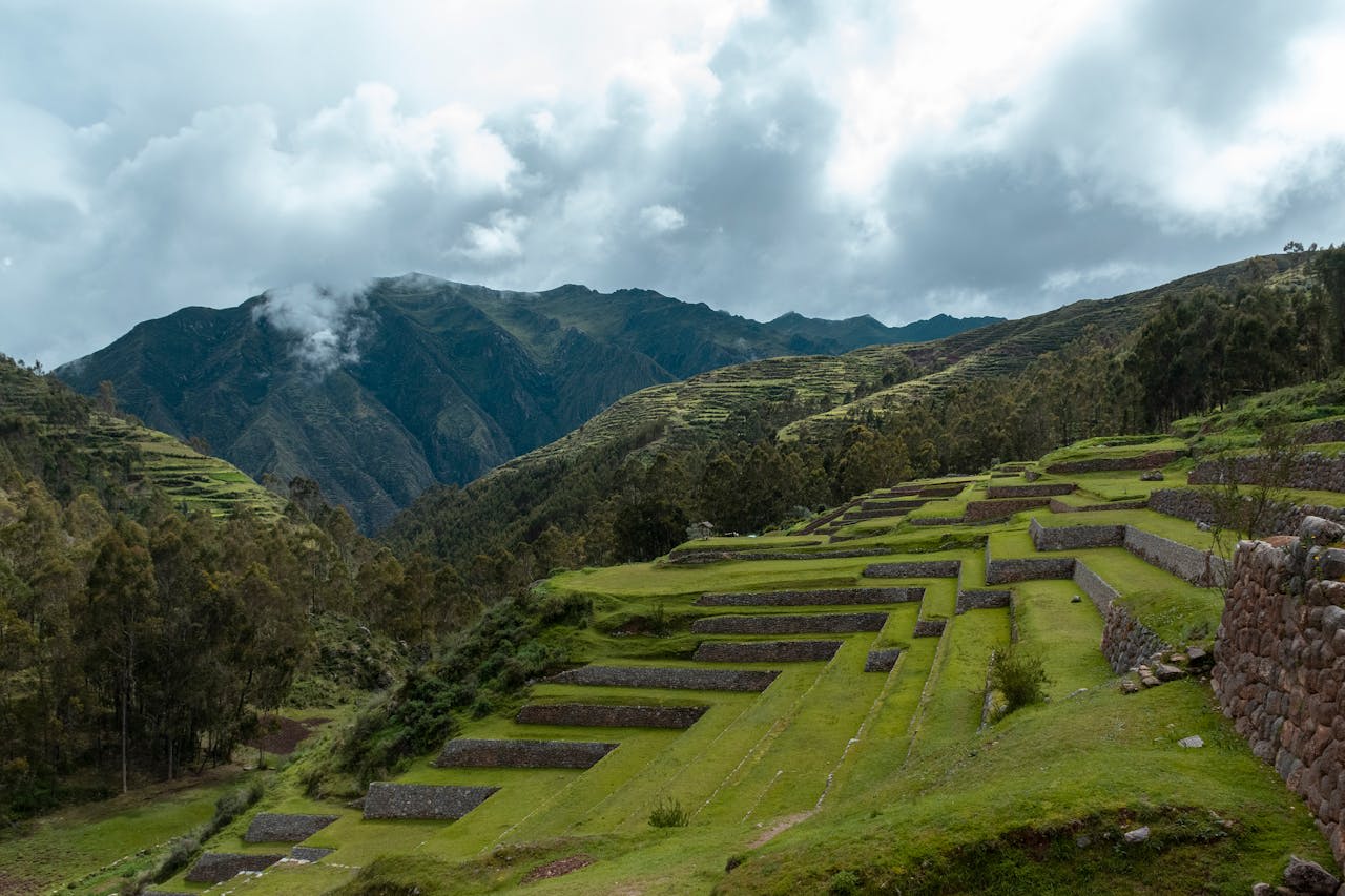
The Sacred Valley of the Incas (Valle Sagrado de los Incas) is the valley of the Urubamba River (Vilcanota) — running northwest from Cusco through Pisac, Urubamba, and Ollantaytambo to the lowlands of the Amazon basin, a distance of approximately 100 km. At elevations of 2,700–3,100 m, the valley floor is warmer and lower than Cusco and was the agricultural heartland of the Inca Empire — a landscape of exceptional fertility transformed by one of the most sophisticated agricultural terrace systems (andenes) ever devised, with over 50 Inca sites including major ceremonial centres, storage complexes, royal estates, and fortresses. The valley was sacred to the Incas because the Urubamba River was considered a terrestrial mirror of the Mayu (Milky Way), and the alignment of Inca sites along the valley reflects precise astronomical observation. Today the Sacred Valley is the core of Inca heritage tourism in Peru — the valley between Pisac and Ollantaytambo contains more concentrated Inca archaeology per kilometre than any other location in South America, while the surrounding Andes provide a landscape backdrop of dramatic snow-capped peaks rising to 5,000+ m directly from the valley floor.
🌍 Geography and Ecosystem
- Pisac: The Inca site of Pisac (accessible by trail from the village, 7 km) is the finest hilltop complex in the Sacred Valley — a ceremonial and agricultural centre combining an intihuatana (sun-stone astronomical observatory), a large cemetery of hundreds of tombs carved into the cliff face, and terracing systems descending from the 3,800 m summit to the valley floor 800 m below. The agricultural terraces at Pisac are the most photographed in Peru after Machu Picchu — their curved form following the hill contours in graceful arcs of dressed stone. The Pisac Sunday market in the village below draws Quechua vendors from surrounding communities in traditional dress selling textiles, produce, and crafts.
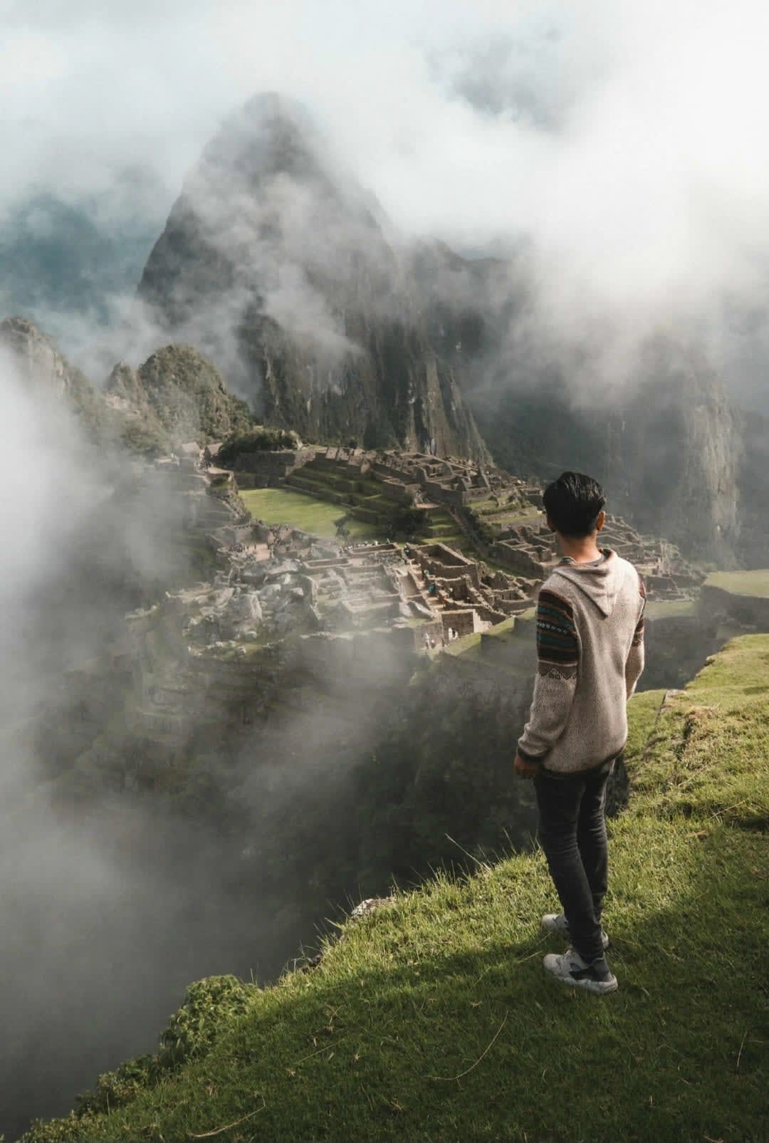
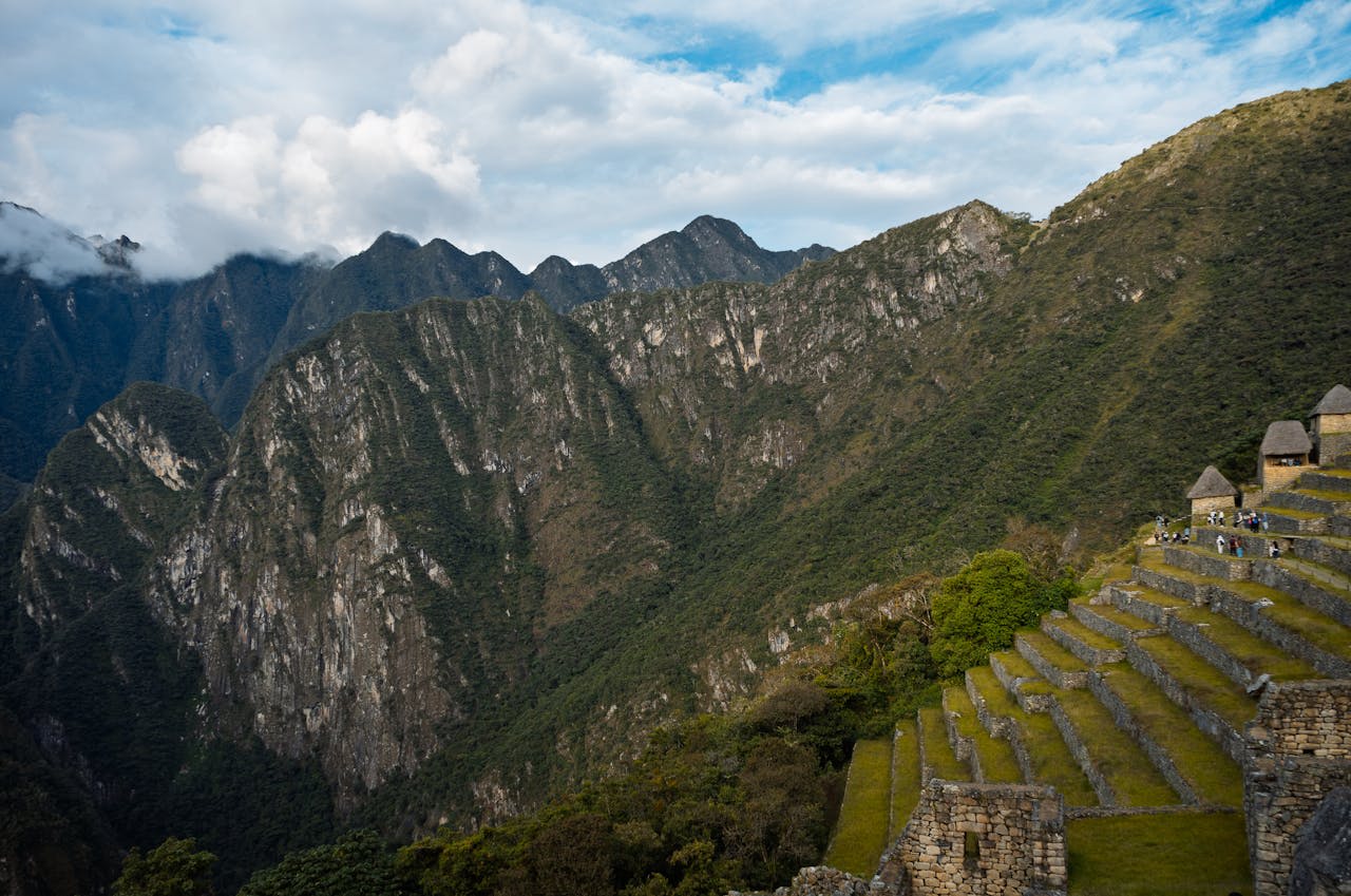
- Ollantaytambo: The fortress-temple complex of Ollantaytambo at the northwest end of the Sacred Valley is the finest surviving example of Inca urban planning and military architecture — a working Inca town layout (the llaqta) still inhabited today, with six massive agricultural terraces rising 60 m above the town flanked by sheer cliffs, and a Temple of the Sun on the summit constructed from pink granite monoliths weighing 50–150 tonnes brought from a quarry 6 km away across the Urubamba River. Ollantaytambo is also the trailhead for the Inca Trail to Machu Picchu and the Vistadome train departure point for Aguas Calientes.
- Moray: The circular terraced depressions of Moray — three concentric amphitheatre bowls cut into the high plain above the valley, the largest 30 m deep with 12 circular terraces — are interpreted as Inca agricultural research stations, designed to test crop varieties at different microclimates created by the bowl geometry. Each terrace level is 1.5–2°C warmer than the one above, creating a temperature gradient of 15°C from top to bottom — effectively simulating the climate of different altitude zones. The geometry of the three bowls, rising from their dark centres in concentric stone rings, is one of the most visually striking Inca constructions.
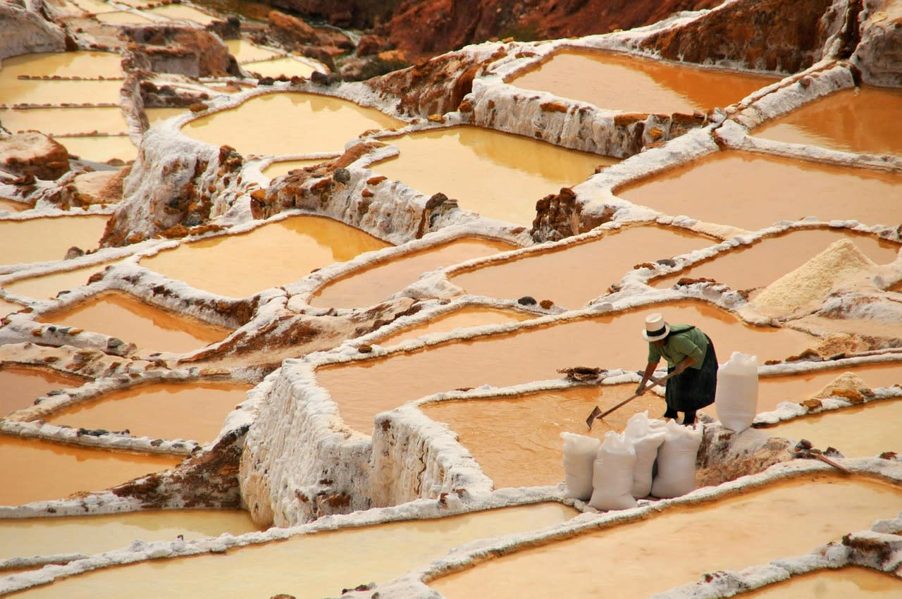
- Maras Salt Mines: The Maras salinas — approximately 3,000 small evaporation pools carved into the hillside above the village of Maras, fed by a natural brine spring and used to produce pink and white salt since Inca times — are one of the most visually remarkable landscapes in the valley. The pools (each 4–8 m², leased to individual families) turn shades of pink, white, and ochre depending on the salt concentration and season. The spring produces brine of approximately 10% salinity at constant temperature year-round, and the salt produced (a pink mineral salt with trace minerals from the aquifer) is sold throughout Peru as a premium product.
📜 History and Cultural Significance
The Spanish conquest (1532–1535) used the Sacred Valley as a military corridor — Manco Inca's resistance army made its last stand at Ollantaytambo in 1537, defeating a Spanish force before ultimately retreating to Vilcabamba in the jungle to the west. The valley's indigenous population was devastated by disease and forced labour in the colonial period, declining from an estimated 150,000 in 1532 to fewer than 20,000 by 1600. The Quechua communities that survived — maintaining the agricultural terraces, the textile traditions, and the seasonal ceremonies that blend Inca and Catholic practice — are the living continuation of the valley's civilisational heritage, and the Sunday markets at Pisac and Chinchero are as significant culturally as the archaeological sites.
🏃 Activities and Attractions
- Pisac Ruins and Market: The hilltop Pisac ruins (7 km walk or taxi to upper entrance) reward early morning visitors — clouds often clear by 9am to reveal the full terrace system against the valley backdrop, and the ruins are empty before the tour groups arrive from Cusco. The Sunday market in the village below operates from 9am–3pm and is one of the most authentic indigenous textile and craft markets in Peru, drawing Quechua vendors from highland communities across the Pisac district in traditional dress varying by village.
- Ollantaytambo Fortress: The Ollantaytambo site (entrance from the village's main square) is the most architecturally significant site in the Sacred Valley — the terraces, ceremonial platforms, and carved stone of the Temple of the Sun (unfinished at the time of the Conquest and now showing the original construction methods) reveal Inca stone-working at a scale and precision comparable to Machu Picchu. Dawn visits from Ollantaytambo village (a 10-minute walk to the site entrance) encounter the ruins in horizontal morning light before the day-trippers arrive from Cusco.
- Maras-Moray Day Trip: Combining the Maras salinas (30 minutes from Urubamba by road) and Moray circular terraces (15 minutes further) in a half-day circuit is one of the most rewarding short excursions in the valley — delivering two uniquely photogenic Inca-era landscapes (the salt pools and the circular agricultural depressions) that are largely crowd-free compared to Pisac and Ollantaytambo. Cycling from Maras to Moray (12 km circuit on paved and dirt roads through highland agricultural landscape) is available through valley bike operators.
- Inca Trail to Machu Picchu: The classic 4-day Inca Trail from Ollantaytambo (Km 82) to Machu Picchu via three Andean passes (the highest at 4,215 m, the Dead Woman's Pass) is Peru's most celebrated trek — passing through cloud forest, puna grassland, and multiple Inca sites before the Sun Gate descent to Machu Picchu at sunrise on day 4. The trail is limited to 500 people per day (including guides and porters) and permits must be booked 6–12 months in advance through licensed operators. The alternative Salkantay Trek (5 days, via the 4,600 m Salkantay glacier) and Lares Trek (3–4 days, through high Andean communities) provide comparable mountain experiences with easier permit access.
💡 Travel Tips
Altitude Acclimatisation: Cusco is at 3,400 m and the valley is at 2,800–3,100 m — altitude sickness is a genuine risk for visitors arriving directly from sea level. Spending 2–3 days in Cusco before arriving, drinking coca tea, avoiding alcohol, and walking slowly are standard acclimatisation measures. The valley is slightly easier at altitude than Cusco and many visitors based in the valley acclimatise more comfortably. Consult a doctor about acetazolamide (Diamox) if prone to altitude sickness.
Best Season: May–October is the dry season — the sky is clear and blue, roads are reliable, and Machu Picchu is at its most photogenic. June–August is peak season: trails, trains, and accommodation are at capacity — book everything months ahead. April and November are shoulder months with fewer crowds and occasional afternoon showers. November–April (wet season) brings daily afternoon rain, muddier conditions, and dramatically less crowded sites; Machu Picchu in mist is arguably more atmospheric than in full sun.
🌱 Conservation
The Inca Trail and the sites receiving concentrated visitor traffic face separate challenges: erosion of the trail surface, damage to site vegetation, and the social impacts of high tourist density on the Quechua communities whose villages adjoin the major sites. The Sernanp (National Service of Natural Protected Areas) management of the Historic Sanctuary of Machu Picchu — which encompasses the Inca Trail and most of the major sites — limits trail numbers and manages visitor flow, but monitoring and enforcement capacity is limited relative to demand. The growing popularity of alternatives to the Inca Trail (Salkantay, Lares, Choquequirao) is distributing some of the impact away from the classic route.