Fox Glacier
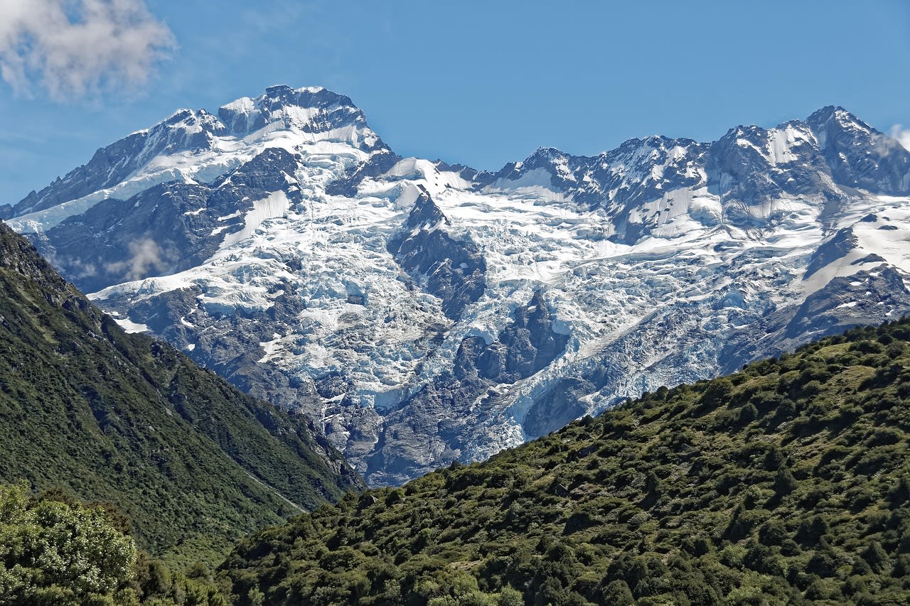
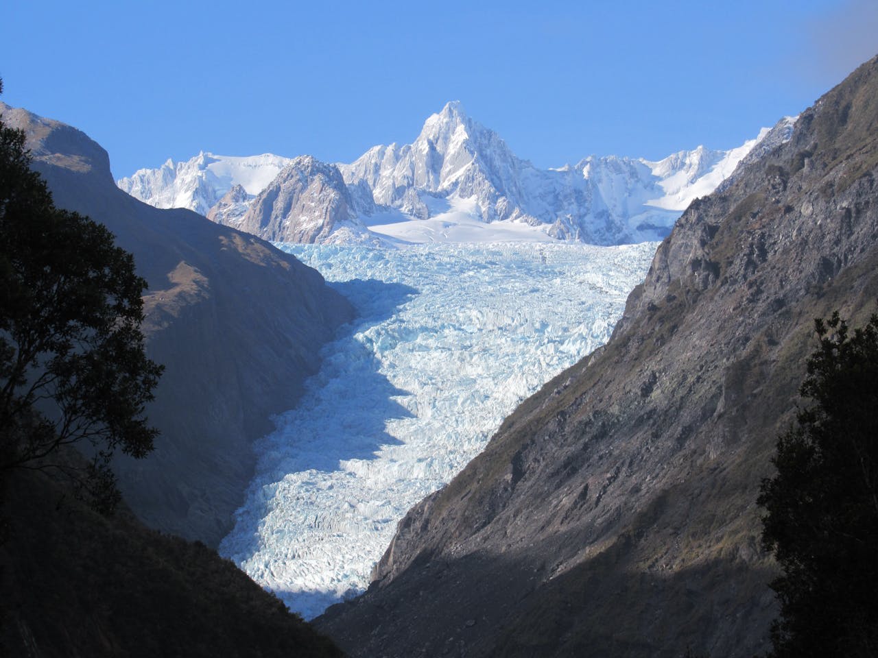
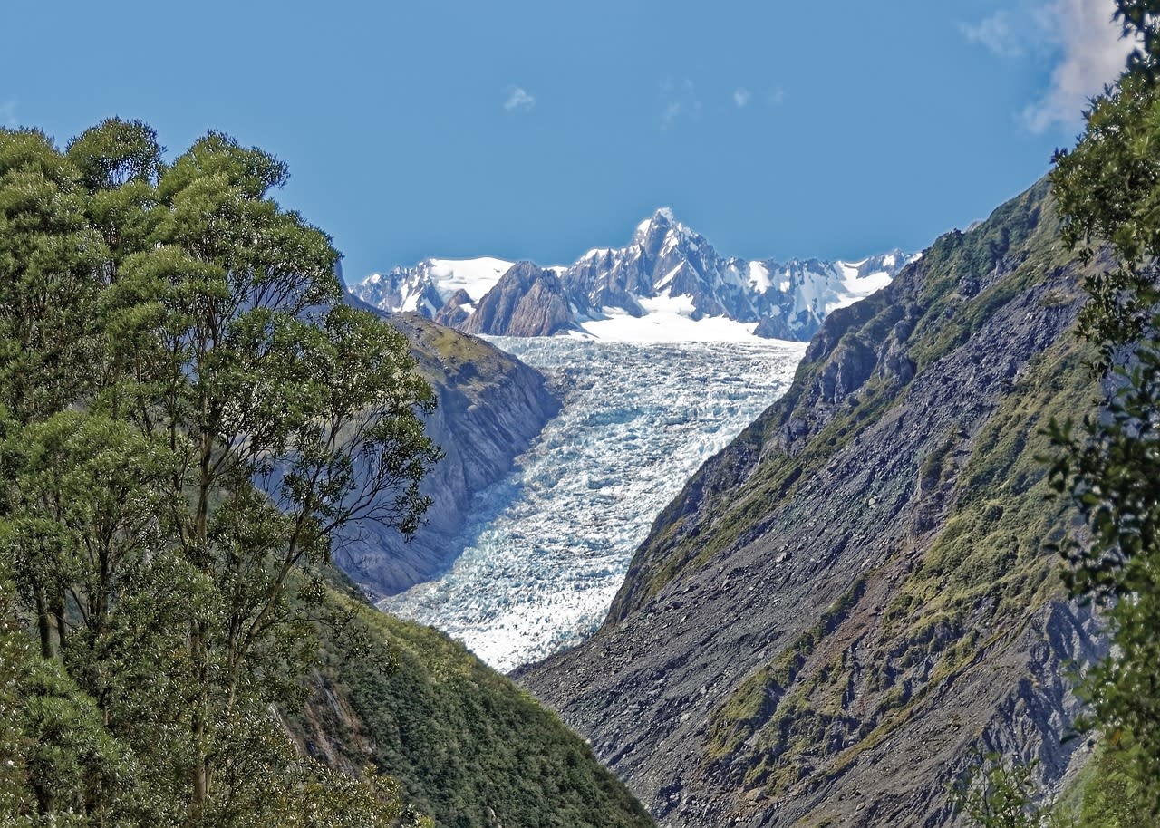
Fox Glacier (Te Moeka o Tūāne — 'the bed of Tūāne' in Māori) is a 13 km temperate glacier in Westland Tai Poutini National Park on New Zealand's West Coast, descending from the Main Divide of the Southern Alps at 2,800 metres to a terminus at just 245 metres above sea level — one of the lowest termini of any glacier outside polar regions. The glacier's accessibility from the Tasman Sea coast (the terminal face is 19 km from the township of Fox Glacier) and its descent through podocarp rainforest of kahikatea, rimu, and silver beech make it a visually extraordinary destination: ice and jungle in proximity that occurs nowhere else in the temperate world. Kā Roimata o Hine Hukatere — the traditional Māori name referring to the frozen tears of Hine Hukatere, a woman whose lover fell from the peaks and was turned to ice by the gods — captures the emotional character of a landscape that combines extreme geological dynamism (the glacier can advance or retreat several metres per day) with encircling rainforest alive with kiwi, kea, and the sound of mountain streams.
🌍 Geography and Ecosystem
- Glacier Valley Walk: A 2-hour return walk from the carpark through the glacial outwash valley to the safety barrier at the glacier terminal face — the closest permitted approach point. The walk crosses braided glacial streams, moraines of recent retreat, and pioneer vegetation zones. Interpretive panels mark the position of the glacier at 10-year intervals, making the scale of recent retreat visually explicit. The terminal face is an active, calving cliff of grey ice — irregular blocks fall without warning.
- Lake Matheson: A 'kettle lake' formed by a stranded ice block from the last glaciation approximately 14,000 years ago, 6 km south of the Fox Glacier township. The lake's dark tannin-stained water creates perfect reflections of the Southern Alps peaks — Aoraki/Mount Cook (3,724 m) and Mount Tasman — in the predawn calm. The 1-hour walking circuit around the lake is one of New Zealand's most-visited viewpoints. The reflection is best October–April before the westerly winds disturb the surface.
- Rainforest Ecosystem: The valley walls flanking the glacier are clothed in kahikatea, rimu, and kāmahi — New Zealand's temperate rainforest species that survived the last glaciation in ice-free refugia on the West Coast. The forest is habitat for the South Island kiwi, kea (the world's only alpine parrot), tōtara, and the native long-tailed bat. The combination of high rainfall, mild temperatures, and high biological productivity makes the West Coast rainforest one of the most intact temperate forest ecosystems in the Southern Hemisphere.
- Fox Glacier Township: A small service village of 350 permanent residents that exists entirely to support glacier tourism. The township has a strong adventure tourism infrastructure — guiding companies, equipment hire, a helipad, and cafes. The township's dependence on glacier tourism creates a direct economic interest in the glacier's health that is observable in the community's engagement with glacier science and climate change communication.
📜 History and Cultural Significance
European discovery of the glacier was by geologist Julius von Haast in 1865, who named it after the then-Premier of New Zealand, William Fox. The West Coast was accessible only by sea until the Haast Pass road was completed in 1965, isolating the coastal communities and giving the region its character as a remote frontier. Glacier tourism developed from the 1930s with guided ice-walks — the classic Fox Glacier activity was walking on the ice surface with crampons, guided by specialists who cut steps in the ice. Changing glacier dynamics from the 2010s made ice walking increasingly dangerous as the surface became more crevassed, and guided glacier walks were suspended from 2019. Helicopter-accessed ice walks — landing on the upper glacier rather than hiking from the terminal — are now the primary ice experience.
🏃 Activities and Attractions
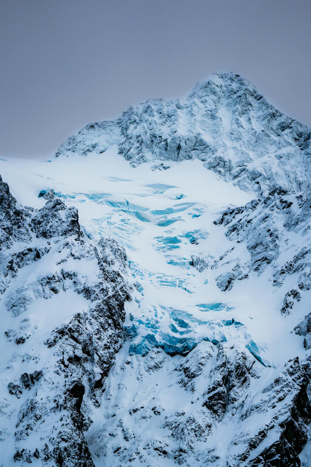
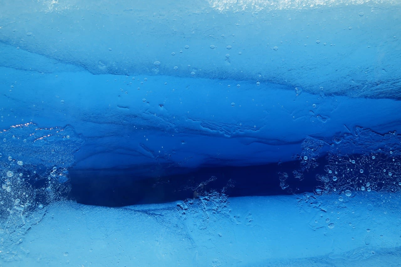
- Helicopter Ice Walk: A 10-minute helicopter flight from Fox Glacier township lands on the upper glacier at 500–1,000 m elevation — above the crevassed lower section — where guides lead 2–3 hour walks on stable glacier ice, exploring ice caves, seracs, and blue ice features. The upper glacier surface is an extraordinary environment: silent except for meltwater, surrounded by the Main Divide peaks, and coloured in the spectrum from white to deep electric blue in crevasse walls. Weather cancellations are frequent — book flexible tickets.
- Glacier Valley Walk: The free 2-hour return walk from the carpark to the glacier terminal viewpoint is accessible to all fitness levels and provides clear understanding of the glacier's recent retreat through interpretive panels. Guided walks from the carpark explain the glacier's geology and ecology in more depth. The outwash river — carrying suspended glacial sediment in a milky grey torrent — is impressive at all water levels.
- Lake Matheson Dawn Walk: Arriving at Lake Matheson in the dark to be in position at the lakeside viewpoint as the predawn light turns the Mount Cook and Mount Tasman reflections pink — one of the most reliably beautiful dawn experiences in New Zealand. The 1-hour circuit allows photography from multiple angles as the light changes. The best conditions are still, clear mornings with no wind — the lake's reflection disappears within minutes of any surface disturbance.
- Gillespies Beach: A wild 17 km beach of black sand and driftwood at the mouth of the Fox Glacier outwash river, 25 km from the township, where ancient forest grows to the high tide mark and elephant seals haul out on the beach in winter. The beach is accessible only by a short walk through kahikatea forest — a reminder that the wild West Coast exists in its entirety, not just in the glacier valley.
- Rainforest Walk and Kiwi Spotting: The forest around Fox township is active South Island kiwi habitat — nocturnal guided kiwi walks operate from the township. Kiwi calls — a strange, high-pitched repeated whistle — are reliably heard in the forest at night even when the birds are not visible. The diurnal forest is equally rich: kea parrots investigate parked cars on the glacier road with destructive curiosity, and tui, bellbird, and fantail are abundant in the rainforest.
💡 Travel Tips
Best Season: October–April for the best weather windows for helicopter operations and the calmest Lake Matheson reflections. July–September are the most reliable for settled weather but shorter daylight hours. The West Coast is one of New Zealand's wettest regions year-round — multiple consecutive days of rain are common in any season. Always book helicopter activities with flexible cancellation policies; weather days are guaranteed.
Accommodation: Fox Glacier township has a limited range: The Distinction Fox Glacier Te Weheka (the largest and best-appointed), several small motel and lodge options, and a backpacker hostel. Franz Josef township 23 km north has a wider range. Book well ahead November–March when West Coast tourism peaks.
🌱 Conservation
The surrounding Westland Tai Poutini National Park protects the rainforest ecosystem in good condition — the primary threats to the forest are introduced stoat and possum populations, which prey on native birds (including kiwi and kea) and browse the forest canopy respectively. DOC (Department of Conservation) operates extensive stoat trapping and 1080 poison drops across the national park to control introduced predators, allowing kiwi populations to maintain viable breeding productivity. The kea — an intelligent and charismatic alpine parrot classified as Endangered — is poisoned incidentally by 1080 operations in some areas, creating a conservation management tension that has not been fully resolved.