


Seoraksan National Park
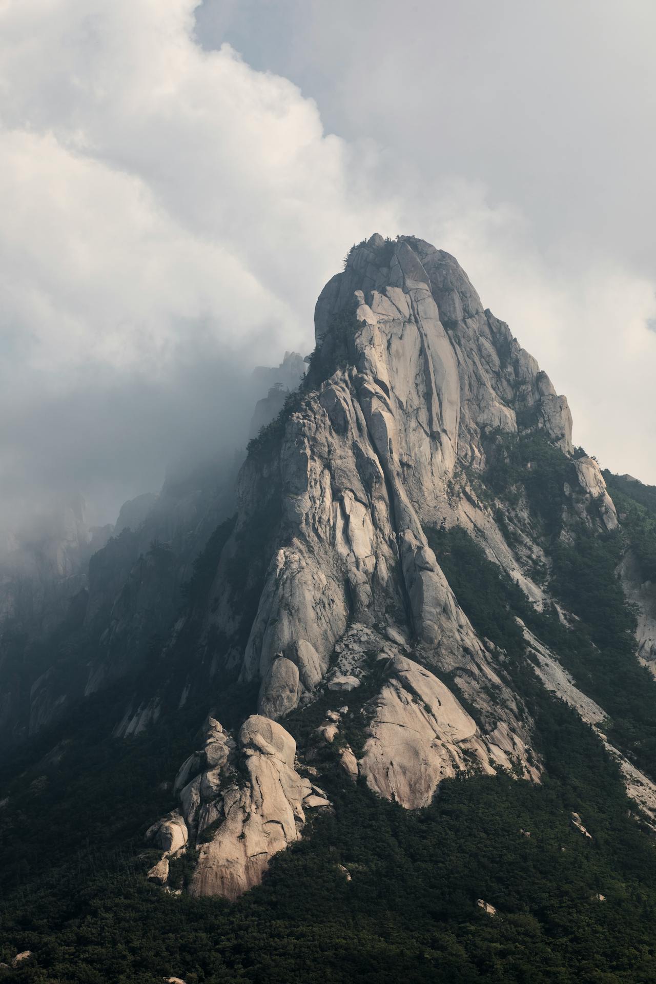
Seoraksan National Park is a 398 km² protected mountain landscape in Gangwon Province, northeastern South Korea — the country's third largest national park and consistently rated by Koreans as their finest. The park's centrepiece is Seoraksan (snow-capped mountain), whose highest peak Daecheongbong (1,708 m) is the third highest in South Korea and one of the most compelling summits on the Korean Peninsula — a granite massif rising sharply from the East Sea (Sea of Japan) coastline on the east and from the broader Taebaek mountain range on the west. The park is equally famous for its dramatic granite rock formations — particularly the towering six-pinnacle Ulsanbawi rock mass (873 m) visible from the park entrance — its concentration of Buddhist temples and hermitages built into the cliff faces and valley floors, and its exceptional autumn foliage (단풍, *danpung*), which begins at the summit in late September and moves down the slopes through October in a colour cascade that draws millions of Korean visitors annually. The park was designated a UNESCO Biosphere Reserve in 1982.
🌍 Geography and Ecosystem
- Ulsanbawi Rock Formation: The Ulsanbawi is a cluster of six massive granite pinnacles rising 873 m above sea level at the north end of the park — a 1.3 km broad rock mass with near-vertical cliffs on three sides, accessible by a 3.9 km trail (800 steps in the final section on iron ladders and staircases fixed to the cliff face). The view from the Ulsanbawi summit ridge delivers a panorama of the full outer Seorak massif and, on clear days, the East Sea coast. The trail to Ulsanbawi is the busiest in the park and should be walked early morning to avoid crowds in autumn season.
- Daecheongbong Summit (1,708 m): The highest point in Seoraksan — accessible via a 7.6 km trail from the Osaek area or a 9.5 km trail from the Outer Seorak entrance. The summit requires an overnight stay at the Daecheongbong mountain hut (book through the Korea National Park Service in advance) for dawn summit views. Above the treeline at 1,500 m, the summit terrain is open rocky ridge with views across the Taebaek mountains and the East Sea coast from Sokcho to the Geumgang Mountains of North Korea to the north on clear days.
- Biryong and Towangseong Falls: The valley floors of Outer Seorak contain several accessible waterfalls — Biryong Falls (2.4 km from Sogeumgang, 70 m drop from a granite overhang) and Towangseong Falls (visible from an observation deck, 320 m cascade — one of the longest in Korea, frozen in winter into an ice climbing venue). The falls valleys contain the most concentrated autumn foliage in the park as the maple-dominated forest is sheltered from wind and the colour intensity is maximised by the valley microclimate.
- Sinheungsa Temple: The Sinheungsa (神興寺) Buddhist temple complex — one of the oldest Buddhist temples in Korea, traditionally founded in 652 AD — sits at the entrance to the main Outer Seorak valley, its wooden halls and pagodas set in old-growth forest beneath the Ulsanbawi cliff face. The temple's 14.6 m bronze Tongil Daebul (Unification Buddha) statue, erected in 1997 as a symbol of Korean reunification aspiration, sits on a platform with the Ulsanbawi formation directly behind — one of the most arresting Buddhist landscape settings in Korea.
📜 History and Cultural Significance
The city of Sokcho on the East Sea coast east of the park was developed as the main gateway city in the 1970s–1980s when Seoraksan was established as a national park and highway infrastructure improved access from Seoul (3 hours). The park now receives 3–4 million visitors annually, primarily Korean domestic tourists — the autumn foliage season generates peak traffic comparable to the most visited national parks in the world.
🏃 Activities and Attractions
- Ulsanbawi Trail: The 3.9 km trail to the Ulsanbawi summit ridge (3–4 hours round trip) is the single most rewarding moderate hike in the park — the final 800 steps of iron staircase on the cliff face are physically demanding but deliver access to a dramatically exposed granite ridge with 360° mountain views. The trail through Heundeulbawi (a rocking boulder) and past Gyejo-am hermitage carved into the cliff is the most atmospheric approach in all of Outer Seorak. Start before 8am in autumn to avoid queues on the staircase section.
- Daecheongbong Overnight: Hiking to the Daecheongbong summit for sunrise — staying overnight at the Korea National Park Service mountain hut — is the most rewarding Seoraksan experience for fit hikers. The hut must be booked online at the Korea National Park Service website (reserve.knps.or.kr) months in advance for autumn weekends. The ridge walk above treeline at dawn, with cloud sea filling the valleys below and the East Sea on the horizon, is the quintessential Korean mountain experience.
- Autumn Foliage Viewing: Seoraksan's autumn colour is considered the finest in South Korea — the combination of maple (danpung), birch, and oak in the valley forests and the granite rock backdrop creates a colour intensity matched by few Asian mountain landscapes. The peak colour window at lower elevations is typically the third week of October. The Seorak cable car (Outer Seorak, ascending to Gwongeumseong fortress ruins at 800 m) provides access to the colour canopy from above without hiking. The cable car queues in peak autumn can be 2–3 hours on weekends.
- Inner Seorak and Baekdam Valley: The less-visited Inner Seorak section, accessible from the Baekdam Valley entrance on the western side, contains the finest wilderness hiking in the park — a remote valley system leading to Baekdam-sa (a Buddhist temple at the valley head) through old-growth forest of Korean fir, maple, and birch. The valley is 8 km from the entrance gate and is free of the crowds of Outer Seorak on all but peak autumn weekends.
💡 Travel Tips
Best Season: Autumn (late September–late October) is peak season for foliage — book accommodation in Sokcho or the Outer Seorak area 2–3 months ahead for October weekends. Spring (late April–May) delivers cherry blossoms at the valley entrances and magnolia blooms near the temples — excellent and less crowded than autumn. Summer (June–August) is wet season with daily afternoon rain — the waterfalls are at their most powerful but trails can be slippery. Winter (December–February): the park is dramatically beautiful under snow and largely empty of tourists — Towangseong Falls freeze into an ice climbing venue accessible by trail.
Accommodation: Sokcho city (20 min from park entrance) has the widest range. The Park Tourist Hotel inside the park boundary (at the Seorak village) is convenient but pricier and fully booked in autumn. Naksansa beachside area (15 min from park entrance) combines East Sea beach access with Seoraksan proximity.
🌱 Conservation
The park faces overcrowding management challenges particularly in autumn — trail erosion, vegetation damage from off-trail shortcutting, and wildlife disturbance during the peak colour season are documented problems. The Korea National Park Service has implemented timed-entry permit systems for the most popular trails (including Daecheongbong) and is expanding trail paving and erosion control on the high-use routes. Bear (Ursus thibetanus) and goat (Naemorhedus caudatus) are the park's flagship mammals — both monitored annually, with goat populations stable and bear numbers very small (fewer than 10 individuals estimated).