Møns Klint
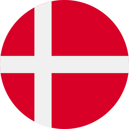
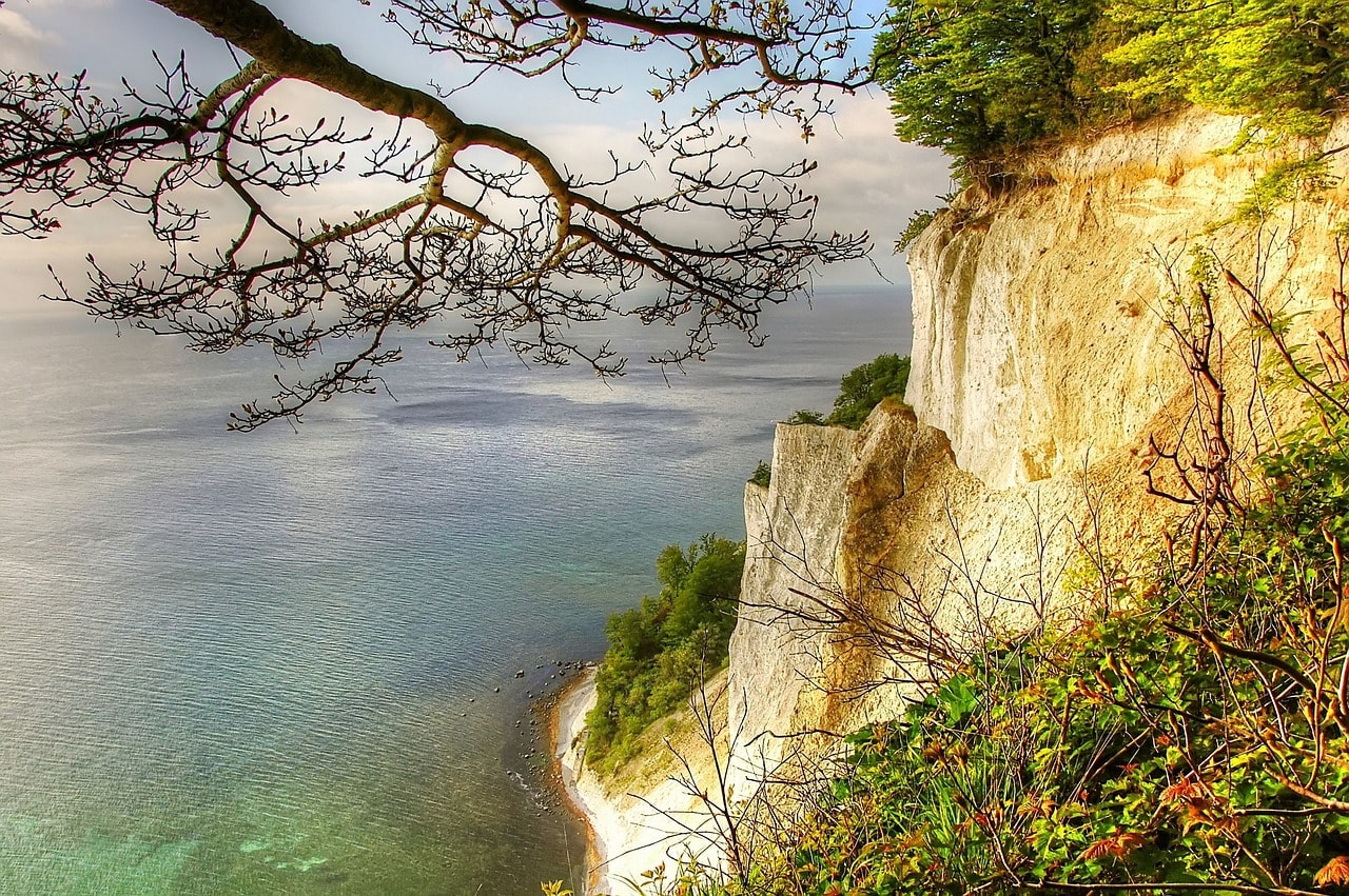
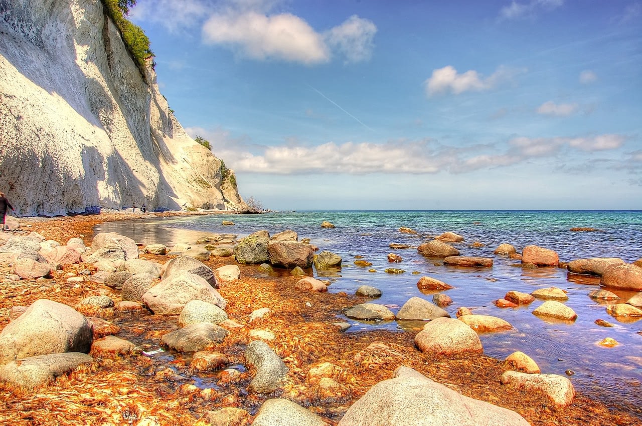
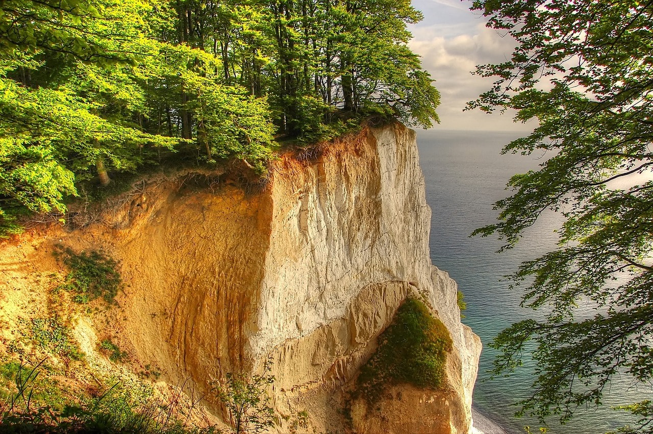
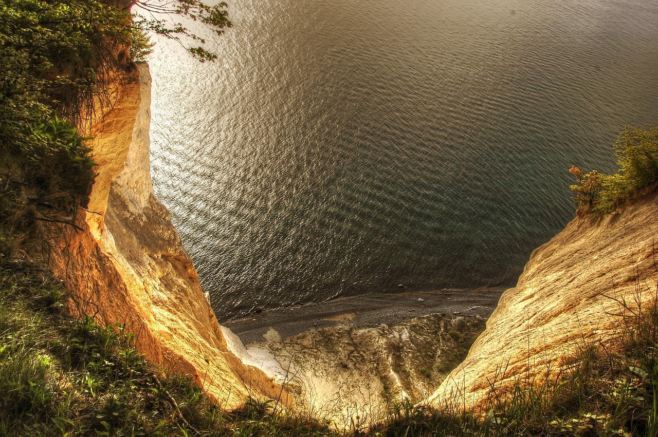
Møns Klint is Denmark's most spectacular natural landscape — a 6-kilometre stretch of gleaming white chalk cliffs on the eastern coast of the island of Møn, rising to a maximum height of 128 metres above the Baltic Sea. Formed from the compacted skeletons of billions of coccolithophores (microscopic marine algae) deposited over 70 million years during the Cretaceous period, the cliffs contain an extraordinary fossil record of ancient sea life including ammonites, sea urchins, and shark teeth. The cliff face has been carved into dramatic blades, towers, and grottoes by 10,000 years of wave erosion since the last ice age, and is crowned by one of Denmark's finest beech forests — Klinteskoven — whose trees grow right to the cliff edge, their roots occasionally exposed as the chalk face collapses. Møns Klint forms the centrepiece of the GeoCenter Møns Klint and the broader UNESCO-listed Stevns–Møn Geopark, recognised for its exceptional geological significance as a record of the Cretaceous–Paleogene boundary event.
🌍 Geography and Ecosystem
- Dronningestolen (Queen's Chair): The highest point of the cliffs at 128 metres, offering a panoramic view north and south along the cliff line and east across the Baltic toward Bornholm. The viewpoint is reached by a well-maintained forest path from the GeoCenter. On clear days the Swedish coast is faintly visible 50 km to the east.
- Fossil Beach: The pebble and chalk-rubble shore at the base of the cliffs is the primary fossil-hunting area, where freshly collapsed chalk reveals ammonites, belemnites, bryozoans, and occasionally shark vertebrae. Fossil collecting by hand from loose material on the beach is permitted; hammering the cliff face is prohibited. The best time to search is after winter storms when new chalk has fallen.
- Klinteskoven Beech Forest: One of Denmark's finest old-growth beech forests, covering the plateau above the cliff edge. The combination of alkaline chalk soil, steep slopes, and southern exposure creates conditions of exceptional botanical richness — the forest floor in spring is carpeted with wood anemone, hepatica, and early orchids including early purple orchid and military orchid. Denmark's largest colony of lesser horseshoe bats roosts in the old beech trees.
- Møns Klint Dark Sky Park: The low population density of southern Møn and the absence of industrial light pollution have earned the area designation as an International Dark Sky Park — one of only a handful in Scandinavia. The chalk cliff tops provide a 180° unobstructed eastern horizon over the Baltic, and on moonless nights the Milky Way is clearly visible to the naked eye. The GeoCenter organises astronomy evenings with telescopes in summer and autumn.
📜 History and Cultural Significance
Møns Klint was discovered by European natural scientists in the 17th–18th centuries, when fossil collection became fashionable among the educated classes. The Danish naturalist Niels Steensen (Steno), generally regarded as the father of modern geology and stratigraphy, studied the fossil shark teeth found in chalk strata along the Danish coast in the 1660s and made the revolutionary argument that fossils were the remains of once-living organisms — a conclusion that transformed natural philosophy. The cliffs became a celebrated destination for Danish Romantic painters in the 19th century, most famously Christoffer Wilhelm Eckersberg and his student P.C. Skovgaard, whose paintings of the chalk cliffs established Møns Klint as a Danish national landscape symbol. The GeoCenter visitor facility, built into the cliff slope in 2007 by architects MLRP, won the Mies van der Rohe Award nomination and is itself considered a landmark of contemporary Danish architecture.
🏃 Activities and Attractions
- Cliff-Top Forest Walks: An 8-km network of marked trails traverses Klinteskoven above the cliff edge, including sections where the path runs within metres of the drop and the Baltic Sea is visible through gaps in the beech canopy 128 metres below. The northern and southern ends of the cliff are the least visited and most atmospherically wild sections, reached by trails from the main carpark.
- Fossil Hunting on the Beach: Descending one of the steep staircase paths (the main access stairs have over 500 steps) to the beach at the cliff foot, visitors search the wave-sorted chalk rubble for Cretaceous fossils. Guided fossil walks are run by the GeoCenter on weekend mornings — guides identify finds on the spot and provide geological context. Best finds: belemnites (torpedo-shaped), sea urchin imprints, and oyster shells preserved in three dimensions.
- GeoCenter Møns Klint: An award-winning visitor centre built into the cliff slope, with immersive exhibitions on Cretaceous marine life, the geology of the Baltic region, the Cretaceous–Paleogene mass extinction event (the asteroid impact that killed the dinosaurs is recorded in the chalk layer here), and the Dark Sky Park designation. The GeoCenter has a rooftop viewing platform and a dedicated children's fossil workshop.
- Cycling Around Møn: The island of Møn has an excellent network of cycle routes through agricultural landscape, beech forest, and coastal meadow. The complete island circuit (approximately 90 km) passes several prehistoric monuments, traditional Danish thatched farmhouses, and multiple sea viewpoints in addition to Møns Klint. Bicycles are available for hire in Stege town, 14 km from the cliffs.
- Dark Sky Stargazing: The Møn Dark Sky Park status makes the cliff plateau one of Denmark's premier stargazing locations. The GeoCenter's astronomy evenings (September–March) use telescopes to observe planets, star clusters, and — in winter — the occasional aurora, whose southern reach occasionally extends over the Danish islands during high solar activity periods.
💡 Travel Tips
Best Season: May–June for spring flora including orchid bloom in the beech forest. Late October–November for autumn colour and quiet. Winter (December–February) for dramatic storm seas and freshest fossil exposure on the beach after gales. Summer is busiest — arrive early (before 10am) for parking at the GeoCenter.
Safety: The cliff edge is unfenced in most sections — do not approach the edge on the cliff-top paths, especially after rain (chalk crumbles when wet). On the beach, maintain a 10-metre clearance from the cliff base as chalk falls without warning, particularly in spring when freeze-thaw cycles are most active. The beach is accessible only at low tide for the full length — check tide tables.
Accommodation: Liselund Ny Slot hotel (in the grounds of the romantic neoclassical estate 2 km north of the GeoCenter) provides atmospheric accommodation with direct trail access to the cliffs. Multiple holiday cottages are available on Møn for multi-day stays.
🌱 Conservation
The beech forest is managed by the Danish Nature Agency as a rewilding zone, with no timber harvesting and a long-term goal of restoring old-growth forest character across the entire Klinteskoven area. Invasive sycamore maple, which was historically planted and now shades out the chalk-loving ground flora, is subject to active removal. The Geopark partnership between Møns Klint and the Stevns Klint UNESCO World Heritage Site to the north — both chalk coastal formations — provides a broader framework for geological tourism, education, and conservation that has attracted EU Interreg funding for trail development and scientific research.