High Fens
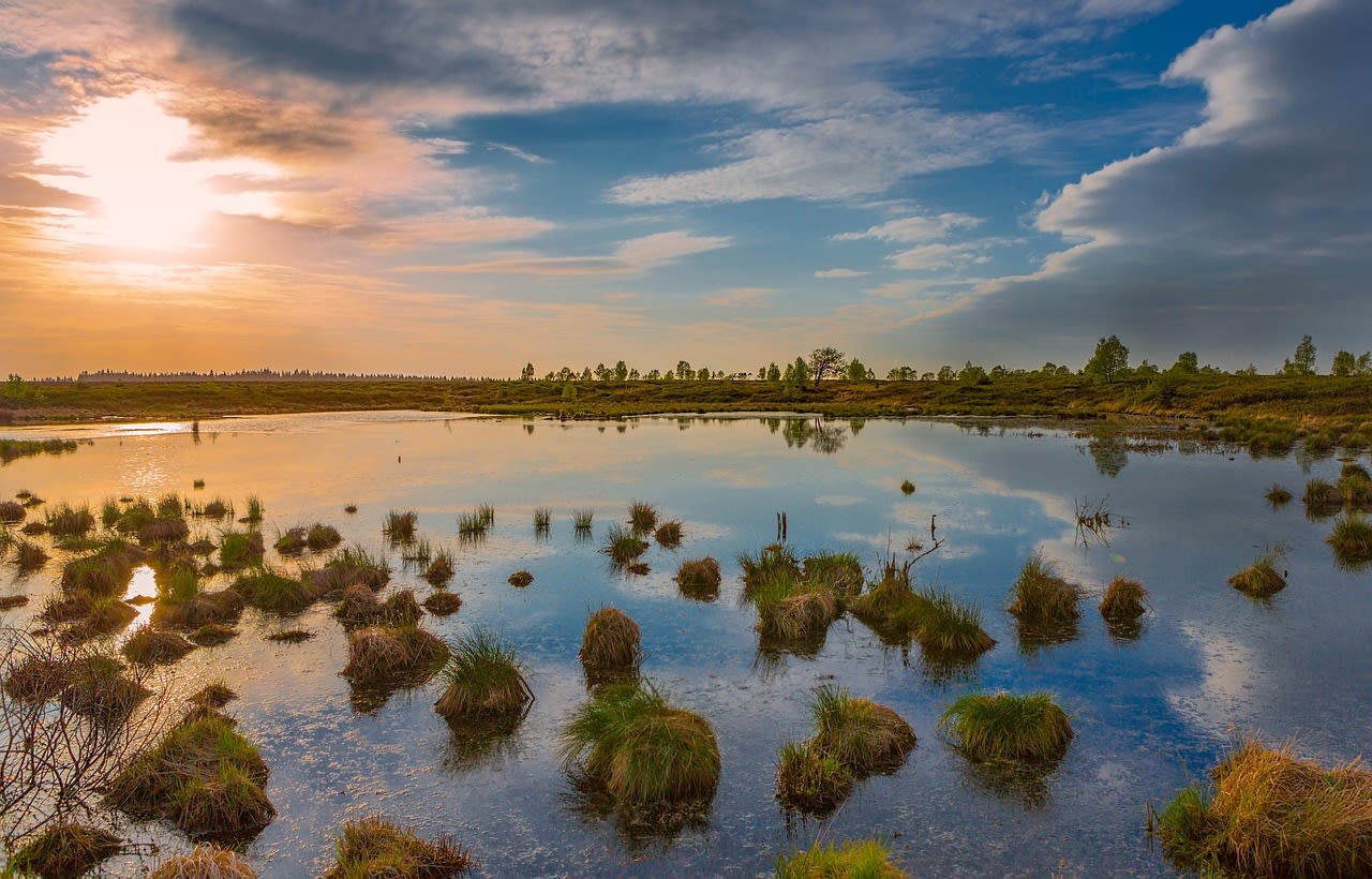
The High Fens (French: Hautes Fagnes; German: Hohes Venn) form the largest nature reserve in Belgium and one of the most important peatland ecosystems in Western Europe — a windswept raised bog plateau straddling the Belgian–German border in the eastern Ardennes, at an altitude of 650–694 metres above sea level. The reserve covers approximately 4,700 km² when including the broader Eifel nature park on the German side, with the strictly protected core Belgian zone encompassing 4,766 hectares of active blanket bog, wet heath, and old-growth forest. The plateau is dominated by vast carpets of sphagnum moss — the peat-forming organism — interspersed with cotton grass, cross-leaved heath, heather, and the carnivorous sundew (Drosera rotundifolia), which catches insects to supplement nutrients absent from the nutrient-poor peat. The High Fens peat body is up to 7 metres thick in places, representing an unbroken record of plant growth accumulating since the last ice age — 9,000 years of climate and vegetation history locked in the stratigraphy. The Signal de Botrange (694 m), the highest point in Belgium, stands at the northern edge of the reserve.
🌍 Geography and Ecosystem
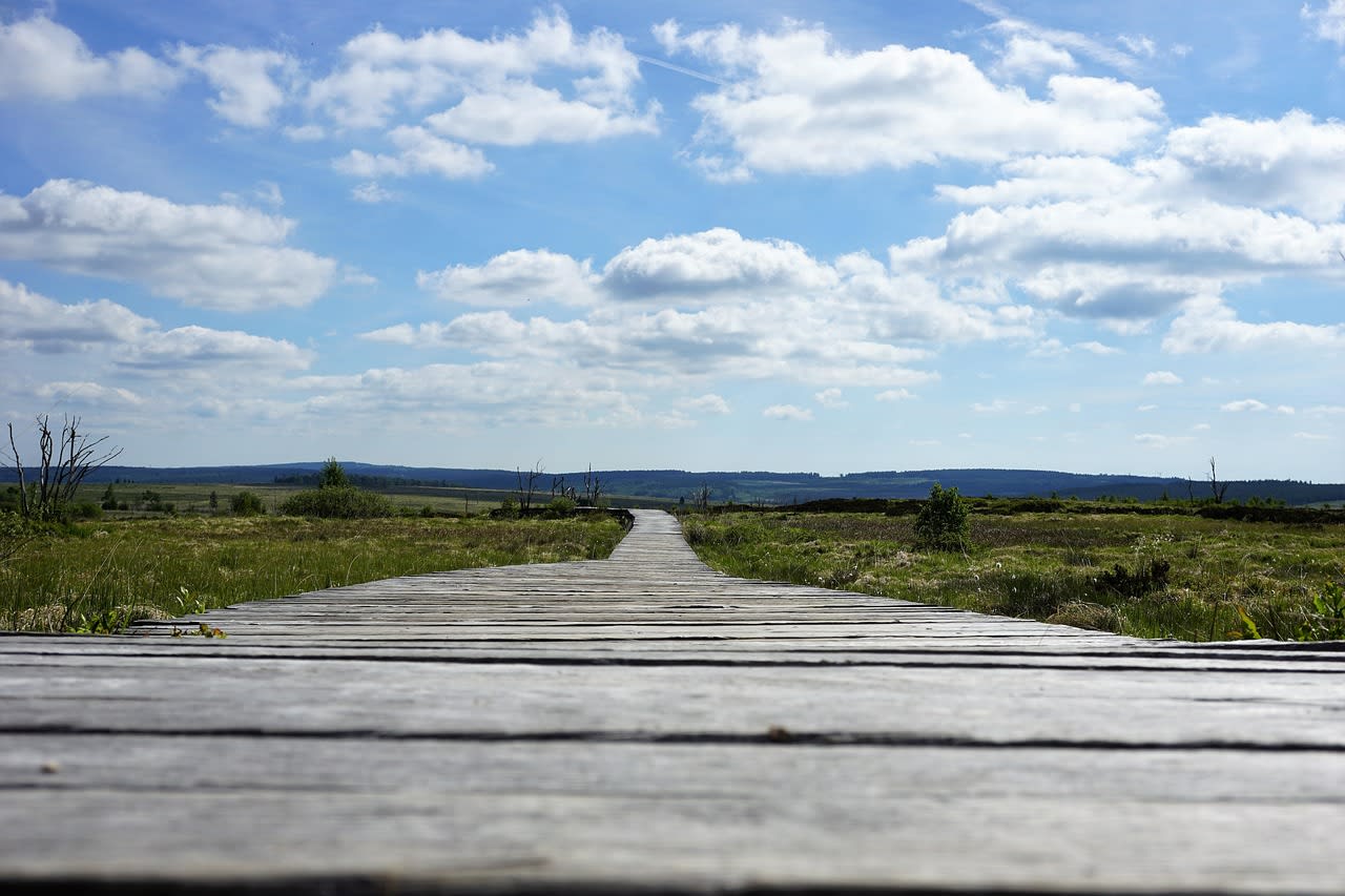
- Brackvenn Raised Bog: The most intact section of active raised bog in the reserve, covering approximately 1,200 hectares of open sphagnum carpet with exceptional botanical diversity. Accessible only via the marked boardwalk system. The bog surface is deceptive — it appears firm but the waterlogged sphagnum can be 3–4 metres deep under the moss layer. Leaving the boardwalk is prohibited and dangerous.
- Signal de Botrange (694 m): Belgium's highest point, marked by a stone tower built in 1932 that adds 6 metres to the natural altitude. The surrounding open plateau gives panoramic views across the fen landscape in all directions on clear days, though cloud and mist are the more common conditions. A modest tourism tower provides context about the plateau ecology and history.
- Baraque Michel Historic Way-Station: An 18th-century stone refuge built in 1808 by Michel Schmitz to shelter travellers crossing the notorious Vennplateau in winter — the high fen was historically a major obstacle on the road between Liège and Aachen, and multiple travellers died of exposure in winter storms before the refuge was built. The building still stands and now houses a café and small historical exhibition.
- Warche Valley Gorges: The rivers draining from the High Fens have carved deep, narrow gorges through the Ardennes sandstone below the plateau edge, particularly the Warche near Malmedy and the Our near Sankt-Vith. The valley walls support old-growth oak and beech forest with populations of wild boar, red deer, and roe deer. The contrast between the open, wind-exposed plateau and the enclosed, sheltered valley floors exemplifies the ecological diversity compressed into a small geographical area.
📜 History and Cultural Significance
The first serious peat-cutting operations began in the 17th century, when peat was commercially extracted for fuel and exported to the cities of Liège and Aachen. By the late 19th century, large-scale drainage and afforestation programmes had converted significant areas of the original bog to spruce plantation. The High Fens Nature Reserve was established in 1957, halting further peat cutting, and subsequent decades have seen the laborious process of rewilding: removing spruce plantations, blocking drainage ditches (over 500 km of ditches have been blocked since 1990), and allowing the natural hydrological regime to recover. The reserve is today one of Western Europe's largest active peatland restoration projects.
🏃 Activities and Attractions
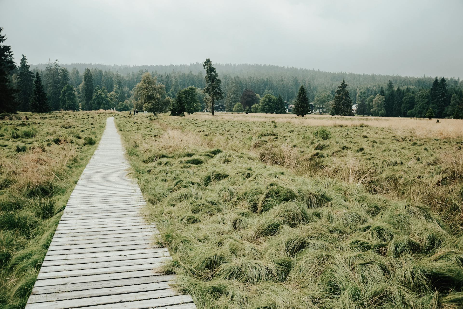
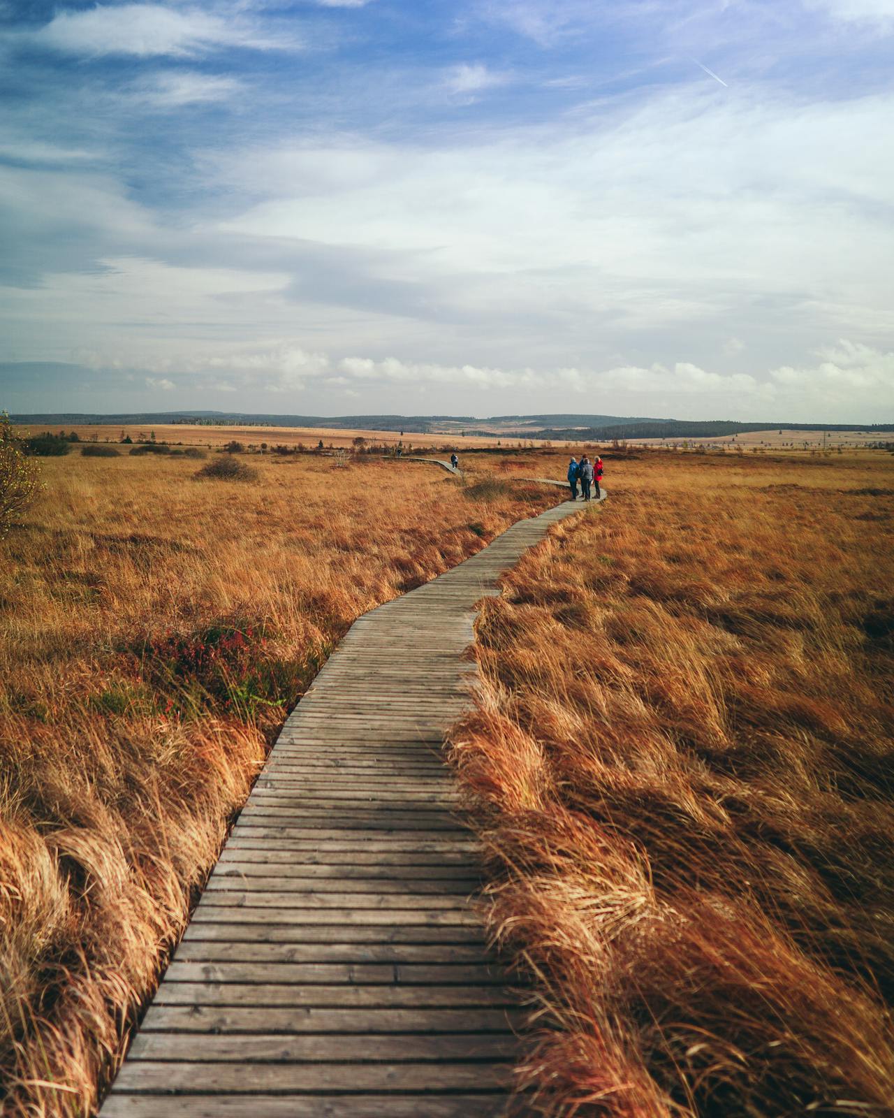
- Boardwalk Trail Walks: The reserve maintains approximately 9 km of wooden boardwalk across the most sensitive bog terrain, including the flagship Brackvenn circuit (4.5 km return from the Botrange information centre). The boardwalks are designed to allow intimate engagement with the bog surface without causing damage — moss, sundew, cotton grass, and crowberry are visible within arm's reach. Morning visits in summer are recommended for dew on spider webs and bog rosemary in flower.
- Black Grouse Watching: The High Fens holds one of Belgium's last remaining black grouse (Tetrao tetrix) populations, with approximately 50–70 males counted in recent surveys. The lek (communal display ground) is active from March to May at dawn, and guided dawn walks from the Botrange centre are organised weekly during this period. Binoculars are essential; noise and sudden movements will abort the display.
- Cross-Country Skiing: In years with sufficient snowfall — which historically occurred reliably but has become less predictable with climate warming — the High Fens provides the only significant cross-country skiing terrain in Belgium. A network of prepared tracks extends across the plateau from Botrange and Baraque Michel, attracting day-visitors from Liège, Aachen, and Cologne when conditions permit. Snow cover of at least 30 cm is typically sufficient for 2–3 weeks in January or February in good years.
- Long-Distance Walking (GR 56 and RAVeL): The GR 56 European long-distance walking route crosses the High Fens as part of its arc through the Belgian Ardennes, and several local waymarked routes (RAVeL) connect the plateau to the valley villages of Malmedy, Stavelot, and Eupen. The 60-km Vennbahn cycle trail follows a converted former railway through the landscape bordering the reserve, passing through German-speaking Belgium and into Germany.
- Geology and Archaeology Trail: A self-guided trail near Baraque Michel visits the preserved sections of Roman road buried under the peat, the ruins of 18th-century peat-cutting operations, and information panels explaining the formation of raised bog and its role as a carbon store. The trail takes approximately 2 hours and requires waterproof footwear.
💡 Travel Tips
Best Season: September–October for heather in full bloom (purple moorland carpet) and early autumn colours in the valley forests. April–May for black grouse lek and first bog flowers. January–February for snow landscapes and possible cross-country skiing. Avoid August bank holidays when parking is severely congested.
What to Pack: Waterproof jacket and trousers are essential at all times of year — the plateau generates its own precipitation and conditions change within minutes. Sturdy waterproof boots for off-boardwalk sections of the wider trail network. Binoculars for birdwatching. The plateau can be 8–10°C cooler than the surrounding valleys even in summer.
Regulations: The core bog zone is accessible only on designated boardwalks and marked paths. Entry off the boardwalk is prohibited for ecological reasons and is also genuinely dangerous — sphagnum bogs can swallow a person. Dogs must be on lead throughout the reserve. The reserve is divided into zones (A=strictly protected, B=controlled access), and the most sensitive sections require a guided tour to visit.
🌱 Conservation
Climate change poses an existential challenge to the High Fens ecosystem: the plateau has warmed by approximately 1.5°C since 1950, and the trend toward warmer, drier summers is increasing the frequency of bog surface fires — historically very rare — which can burn through the dry sphagnum moss layer and release centuries of stored carbon in hours. Three major fires have occurred since 2011, the largest (2011) burning 570 hectares of the core bog zone. Fire prevention infrastructure including water retention pools and firebreak tracks has been installed, and the Belgian Air Component provides helicopter water-bombing support during periods of fire risk. The expansion of invasive birch into the open bog margins is being controlled by mechanical clearance, and the recovery of black grouse populations is supported by predator management on the lek sites.